Szrojt 1947, Obóz zagłady w Bełżcu in Biuletyn Głównej Komisji Badania Zbrodni Niemieckich w Polsce, vol. III (1947), pp. 31-45 , source of the Kozak gas-chamber deposition cited p. 65; the 209-page bound volume is bundled in full
Bełżec Archaeology, Kola 2000 (English Translation)
Working English translation of Andrzej Kola, Hitlerowski obóz zagłady Żydów w Bełżcu w świetle źródeł archeologicznych: badania 1997-1999 [The Nazi Camp for the Extermination of Jews at Bełżec in the Light of Archaeological Sources: Investigations 1997-1999], Council for the Protection of Memory of Combat and Martyrdom (Warsaw) / United States Holocaust Memorial Council (Washington), 2000. 86 pages.
Foreword
[Page 3]
For us, who survived the nightmare of the Holocaust, Bełżec is one of the most painful places connected with that tragedy. More than 600,000 Jews were murdered here, mainly from the territory of the Second Polish Republic. The victims were brought from cities, towns, and villages across an area extending west as far as Chrzanów and Żywiec, and east as far as Tarnopol. Bełżec is the cemetery of the Jews of Stanisławów, Tarnów, Rzeszów, Tarnobrzeg, and many other localities. Bełżec was the end of the history of Jewish communities, the great communities, whose history reached back nearly 800 years. Jews were deported here from Kraków, Lublin, and Lvov, great economic and cultural centers, famous for thinkers who set the canons of contemporary Judaism for centuries. Wise men and simple men, representatives of the small-town Galician intelligentsia, Jewish craftsmen from smaller and larger cities, beggars and bankers, all of them were brought to Bełżec on their last journey. Almost all of Bełżec's victims were Jews. This place has become without doubt one of the most tragic cemeteries of our civilization.
And yet, of the six existing extermination camps, Bełżec appears to be the most forgotten place of memory. The camp about which the least information has survived, of which the fewest people lived through, and whose commemoration is still incomplete. There is no exhaustive scholarly study on what happened here. From scattered accounts an attempt was made to reconstruct the topography of the camp and an approximate number of victims. The data have been placed on information panels at Bełżec and constitute essentially the only source of information about the camp at the place of its existence.
For several years the Council for the Protection of Memory of Combat and Martyrdom has, together with the United States Holocaust Memorial Council, been working on a new monument at Bełżec. We desire on both sides to create a commemoration commensurate with the tragedy that took place. The new memorial place should not only pay tribute to the thousands murdered, but also teach about the tragedy that occurred here.
In 1997 the jury of a closed competition for the Bełżec monument selected the work of an artists' team led by Andrzej Sołyga. In the chosen project the entire camp area becomes the monument. The artists held that the most expressive way of commemorating the victims was the sanctification of the ground that hides their ashes. It is indeed difficult to find a more striking symbol. So that the monument could have an authentic voice, it was necessary to carry out appropriate archaeological investigations to determine accurately the topography of the former camp area and to avoid in future earthworks the places that conceal human ashes. So that we should not, by creating a place of memory, hurt the memory we wish to preserve.
At the commission of the Council for the Protection of Memory of Combat and Martyrdom, and with the substantial involvement of its workers under the direction of Secretary General Andrzej Przewoźnik, a complete series of archaeological survey investigations was conducted over the past three years. The present publication contains its results. Words of great recognition are due to the team of archaeologists from the University of Toruń under the direction of Prof. Andrzej Kola for their professionalism and their devotion to the cause of Holocaust memory. Archaeological work conducted in such a place as Bełżec demands special engagement, painstaking care, and psychological resilience. Prof. Kola's team displayed those qualities and has earned the gratitude of all those for whom the memory of the victims of the Holocaust is dear.
[Page 4]
The task of the United States Holocaust Memorial Council is to commemorate and document the events of the Holocaust. The program aimed at commemorating the victims of Bełżec fulfills this mission in a particularly important way, and the archaeological investigations conducted at Bełżec, and earlier at Chełmno on the Ner, are the seed of future works that should be undertaken also at the remaining places of memory, and especially on the grounds of the former extermination camps.
The results of the investigations carried out at Bełżec constitute unique documentation of the place of the former extermination camp and are an excellent point of departure for historians who would like to work on a monograph on Bełżec. I hope that such a work will soon arise.
Washington, 23 November 2000
Miles Lerman Chairman Emeritus United States Holocaust Memorial Council
Chapter 1: Research Problematics
[Page 5]
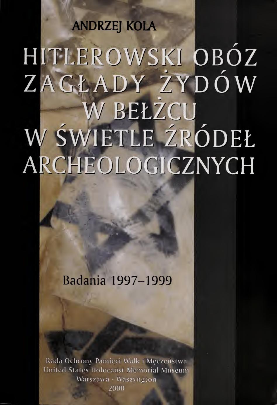
The extermination camp for Jews at Bełżec, like the others, does not possess an adequate source base for the conduct of even superficial investigations into the functioning of this "death factory," in which, according to various estimates, in the course of barely a few months in 1942 at least several hundred thousand Jews1 were murdered. They came chiefly from Eastern Galicia (the prewar voivodeships of southeastern Poland: Tarnopol, Stanisławów, Lvov)2, and also from the contemporary Kraków voivodeship and partially the Lublin voivodeship (including Lublin, Krasnostaw, Zamość, Szczebrzeszyn, Zwierzyniec on the Wieprz, and the nearby Tomaszów Lubelski). Transports of Jews also arrived at Bełżec from more distant areas:
Page 5 of the book. Fig. 1. Map of the Hitlerite extermination camps on Polish soil (after E. Szrojt). Arrows from points across Poland converge on Bełżec, Sobibór, Treblinka, Chełmno, and Auschwitz.
1 In a publication put out by the Main Commission for the Investigation of Hitlerite Crimes in Poland and the Council for the Protection of Memory of Combat and Martyrdom,Obozy hitlerowskie na ziemiach polskich 1939-1945, Warsaw 1979, p. 94, the number of victims murdered at Bełżec is given as around 600,000. The figures here are, necessarily, only estimates.
2 The deportation action from these voivodeships is discussed in detail by T. Berenstein, Eksterminacja ludności żydowskiej w dystrykcie Galicja (1941-1943), Bulletin of the Jewish Historical Institute, No. 61, Warsaw, January-March 1967, p. 41 ff. and p. 1-11 (where the basis of the sources used is also indicated). In a recently published outline of the history of the Jewish railway in Lvov, information is recorded about the direction in 1942-43 of transports of Jews from the Lvov ghetto to Bełżec; see Lwiwska zaliznicia – Istoria i suczasnist', Lvov 1996, p. 37. This information, however, is not entirely accurate, since as is known, the extermination camp at Bełżec functioned only until December 1942.
[Page 6]
From Czechia, Romania, Austria, and Hungary, as well as, though in smaller numbers, from Western Europe such as Belgium, Denmark, the Netherlands, Germany, and Norway. Apart from Jews, Poles were also brought to Bełżec, although in a relatively small number. Among the latter were citizens of Lvov who helped Jews.
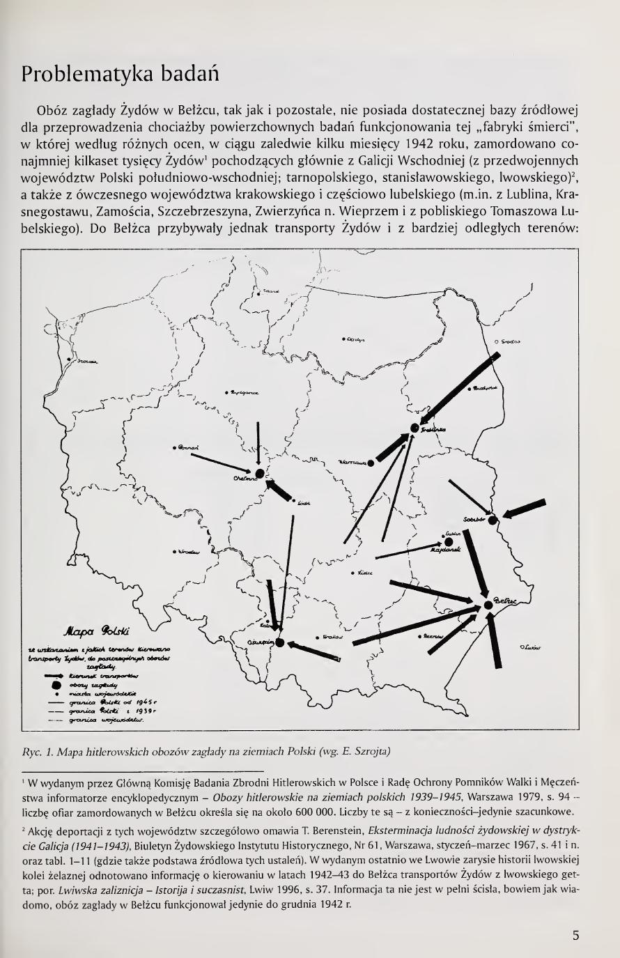
Until recently, knowledge about the functioning of the extermination camp at Bełżec was based on the accounts of a few witnesses, principally inhabitants of nearby Tomaszów Lubelski and of Bełżec itself, whose testimony was recorded in the protocols of the investigation undertaken after the Second World War. In the prosecutorial inquiry conducted at that time in 1945, the area of the camp liquidated by the Germans in December 1942 (whose traces had been erased up to spring of the following year) was inspected, the alleged location of mass graves was probed, and a forensic-medical inspection was carried out on human remains extracted in the course of this excavation3. On the basis of the data thus obtained an attempt was made to reconstruct the layout of the camp, distinguishing two phases of its existence in the period from mid-March 1942 to December of the same year4 (figs. 2, 3).
Page 6 of the book. Fig. 2 (top), orientation plan of the camp in the first period of existence, after E. Szrojt: a, guardhouse, b, guards' barracks, c, undressing room, d, fence around the camp. Fig. 3 (bottom), orientation plan in the second period: a, guardhouse, b, guards' barracks, c, small dressing room, d, large gas chamber, e, graves, f, wooden barracks (housing of the Jewish work team).
3 Copies of the protocols from the prosecutorial inquiry of 1945 the present author obtained from the Archive of the Main Commission for the Investigation of Crimes Against the Polish Nation, Institute of National Remembrance in Warsaw. These are: a/ Protocol from the inquiry into the matter of the extermination camp at Bełżec conducted on 10-13 X 1945; b/ Report on the results of the inquiry concerning the matter of the extermination camp at Bełżec from 12 X 1945 r., together with the protocol of the inspection of the cemetery of the extermination camp at Bełżec from 10 X 1945 r. and forensic-medical opinion of the Court Series; c/ Protocol of the cemetery inspection of the extermination camp at Bełżec from 10 X 1945 r. and forensic-medical opinion. In the Archive of the Council for the Protection of Memory of Combat and Martyrdom in Warsaw, among the copies of aerial photographs of the Bełżec area taken during the Second World War, is a Luftwaffe aerial photograph from 16 May 1944 with traces of earthworks of leveling of the camp area, undertaken without doubt with the aim of erasing the area of the graves; see also: Air Photo Evidence. Auschwitz, Treblinka, Majdanek, Sobibor, Bergen Belsen, Belzec, Babi Yar, Katyn Forest. World War II photos of alleged mass murder camps..., by John C. Ball, Ball Resource Services Limited, Delta B.C. Canada 1992, pp. 92-97.
4 E. Szrojt, Obóz zagłady w Bełżcu, Bulletin of the Main Commission for the Investigation of German Crimes in Poland, vol. III, 1947, pp. 31-45; see also: T. Chróściewicz, Sprawozdanie o wynikach dochodzeń w sprawie obozu zagłady w Bełżcu, Bulletin of the Main Commission for the Investigation of Hitlerite Crimes in Poland, vol. XIII, 1960, pp. 127-130.
[Page 7]
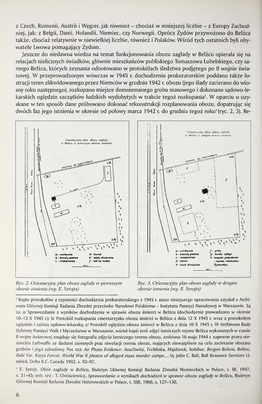
These constructions differ decidedly from the layout of this camp drawn on the basis of the account of R. Reder, the only person who perhaps managed to survive this place of death5 (fig. 4).
The camp at Bełżec was located at a small distance, just over 300 m to the southeast of the railway station in this locality. Directly to the south of the camp[T] ran the railway line from Zwierzyniec through Bełżec to Rawa Ruska, and running here, almost tangent to it, the highway from Zamość through Tomaszów Lubelski, Bełżec and Rawa Ruska to Lvov. From the railway station at Bełżec, already before 1940, a two-track railway siding had branched off onto the area of the later camp, intended for the transport and unloading of Jews destined for extermination6. Mention of its existence is made in all the accounts recorded in the framework of the prosecutorial inquiry conducted in 1945, as the loading-unloading siding leading onto the area destined for extermination. The site of the camp (its southwestern region) thus took in the existing railway infrastructure that was here earlier.
[T]Translator's note. The Polish original reads "Bezpośrednio na południe od obozu przebiegała linia kolejowa…","directly to the south of the camp ran the railway line." This is geographically correct: the December 1942 Luftwaffe aerial photograph of the camp shows the main Lublin–Lvov line running along the camp's southern boundary, with the spur branching from the line at the SW corner and entering the camp from the south. Kola's own figures (Fig. 4, Ryc. 17, the p. 70 fold-out) and Szrojt 1947 (Bulletin vol. III pp. 31–45, who describes the siding as running along the camp's south-western boundary) corroborate this. The contrary claim in Arad 1987 (Belzec, Sobibor, Treblinka, Indiana UP, p. 27), that the spur entered through "the gate on the north side of the camp", is rotated 180° from the aerial-photographic and Polish-investigative record, and inherits the perspectival convention of the 1946 Bau-Reder camp plan (drawn from inside the camp's experiential geography rather than as a north-up cartographic plan) without correcting for it.
In light of the cited reports, the main core of the camp at Bełżec, the place where victims were brought, killed, and buried, covered an area approximating an irregular rectangle with side dimensions: ca. 250 m (northwestern boundary), 250 m (southwestern boundary), 285 m (northeastern boundary) and 205 m (southeastern boundary), reaching an area of about 6 hectares. The camp was located on sandy terrain rising from the southwest toward the northeast, achieving across its expanse a denivelation reaching about 10 m. In the most elevated, eastern part the camp area was, at the moment of its founding (and is currently as well), wooded. The forest still existing today on the northern and eastern sides within the area of the former camp, predominantly pine, constituted a natural cover for this place of execution. At the time of the camp's founding, on its western side, in the layout of [continued next page]
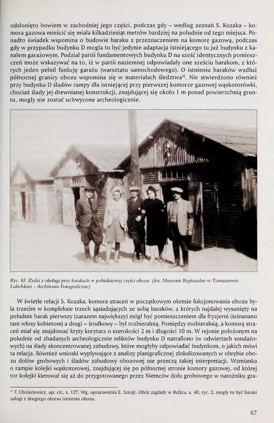
Page 7 of the book. Fig. 4. Plan of the extermination camp drawn on the basis of the account of R. Reder. Labeled structures include the warehouse (Magazyn rzeczowy), kitchen (Kuchnia), separate men's and women's undressing rooms (Rozbieralnia), workshop barracks (Warsztaty fachowcy), gas chamber building (komora), area where men's heads were shaved under Ukrainian guards (strzyżenie głów mężczyzn), women's hair-cutting room (komora golenia głów kobiet), barracks for the Askari (Ukrainian guards) (Baraki dla askarów), and the railway siding (Bocznica kolejowa). Outer labels: camp courtyard (DZIEDZINIEC), forest (LAS), and the gate (OBÓZ ŚMIERCI BEŁŻEC).
5 R. Reder, Bełżec, 1946, published by the Jewish Historical Committee in Kraków, p. 43. Knowledge about the Holocaust from the postwar accounts of witnesses to these events still alive at that time is supplemented by the publication: Czarny rok... Czarne lata..., ed. M. Śliwowska, Warsaw 1996.
6 This siding existed here already before 1940; it can be seen on an aerial photograph taken on 26 May 1940 (a copy of the photograph is in the Archive of the Council OPWiM); Air Photo Evidence..., pp. 93, 94.
[Page 8]
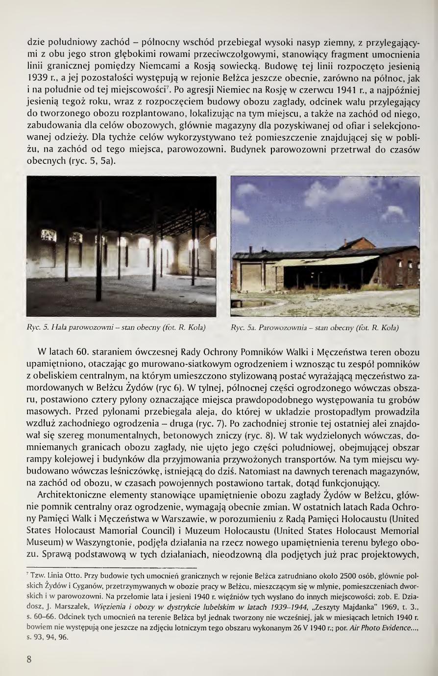
[continuing from page 7] in the layout running southwest – northeast there ran a high earthen rampart, with deep antitank ditches adjoining it on both sides, constituting a fragment of the fortification of the border line between Germany and Soviet Russia. Construction of this line was begun in autumn 1939, and its remains occur in the region of Bełżec even now, both north and south of this locality7. After the German aggression against Russia in June 1941, and at the latest in autumn of that year, together with the beginning of the construction of the extermination camp, the section of the rampart adjacent to the camp being created was leveled, and on this site, as well as west of it, structures were located for camp purposes, chiefly storehouses for the clothing taken from the victims and sorted. For the same purposes use was also made of the building of the locomotive shed (parowozownia) located nearby, west of this place. The locomotive-shed building has survived to the present day (figs. 5, 5a).
Page 8 of the book. Fig. 5, locomotive-shed hall, present state. Fig. 5a, locomotive shed exterior, present state. Both photos by R. Kola. The Otto Line earthen rampart with antitank ditches once ran here SW–NE; the locomotive-shed building survives and was repurposed by the SS as storage for sorted clothing of the victims.
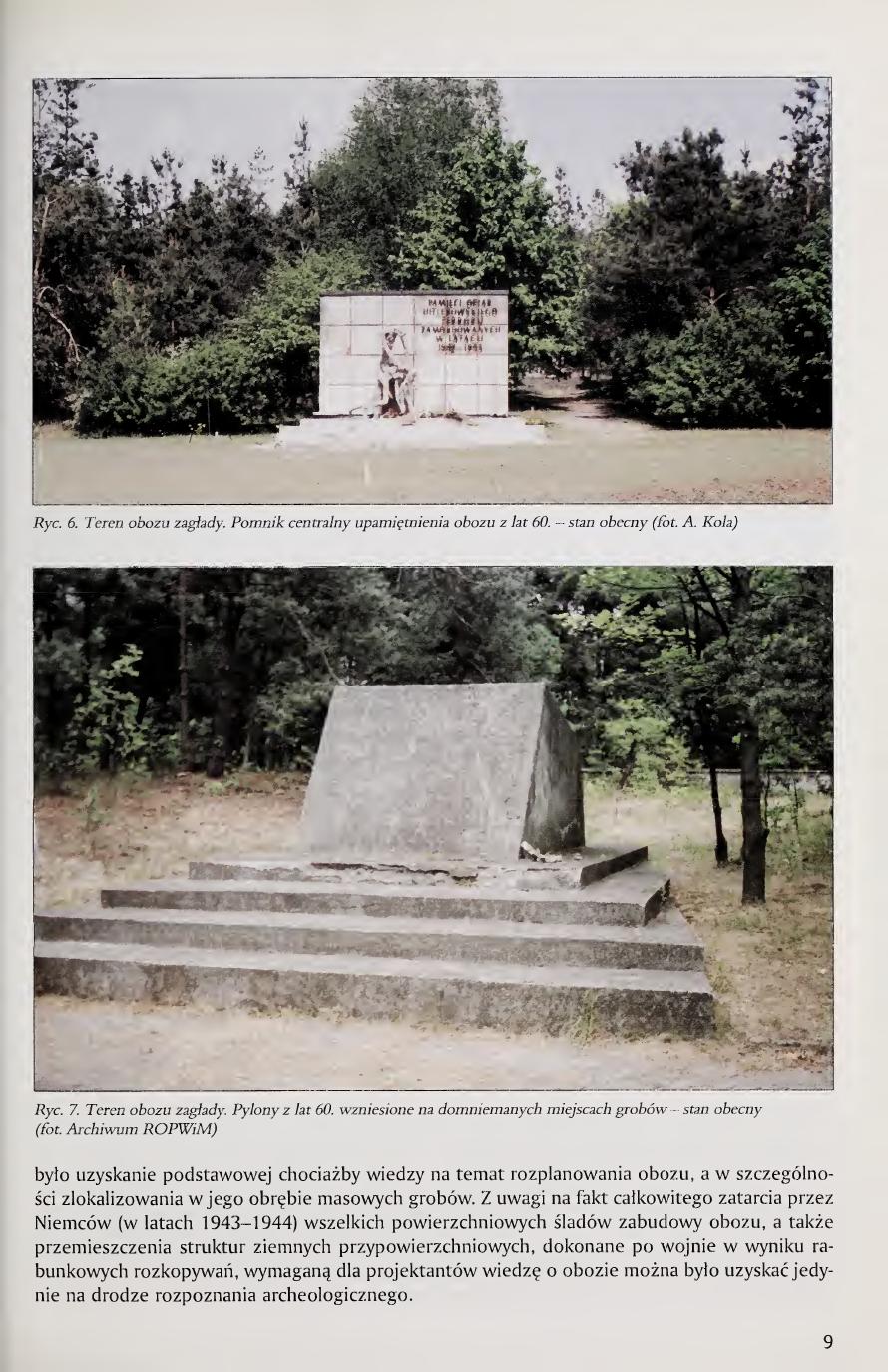
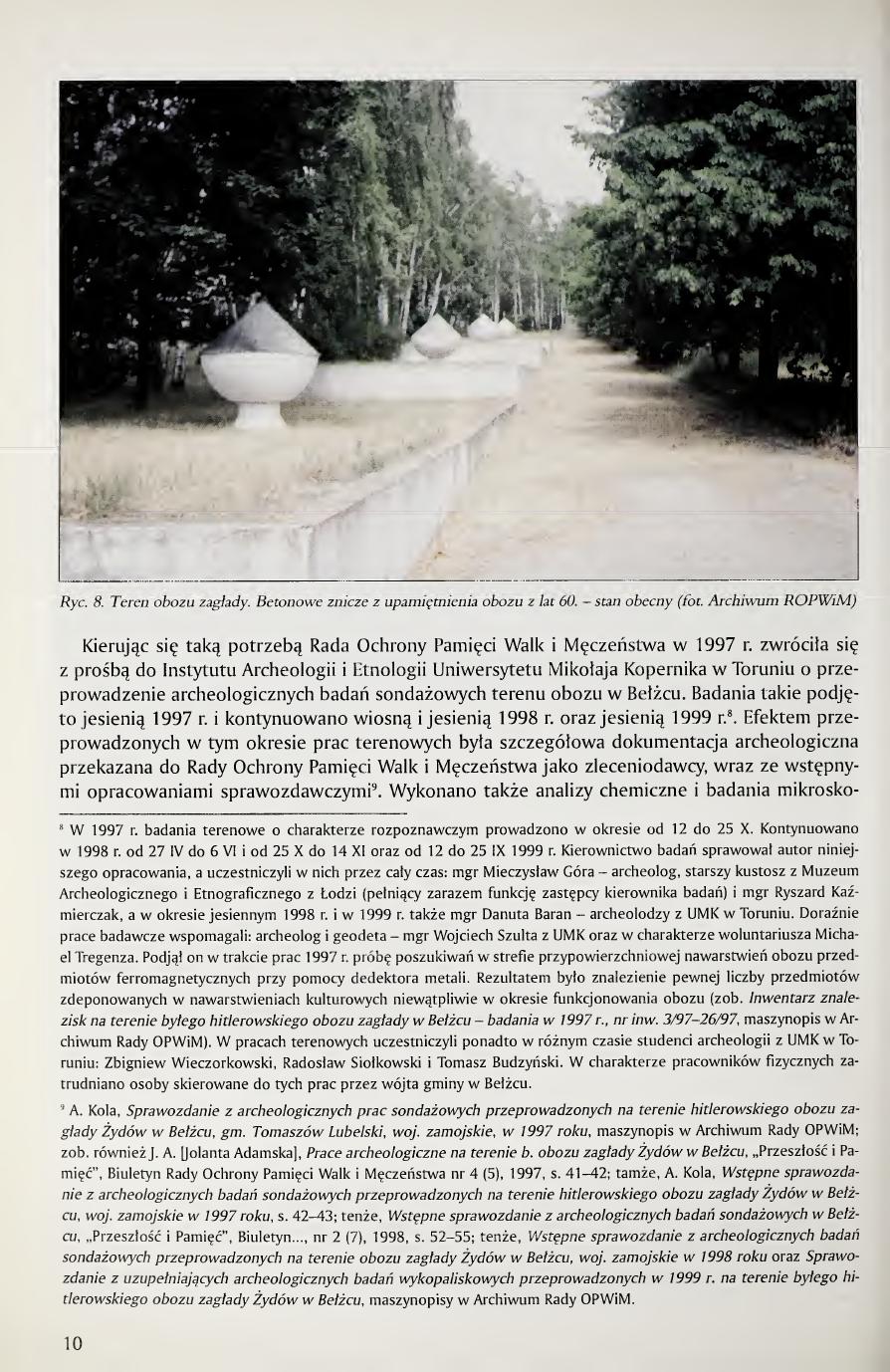
In the 1960s, through the efforts of the then-existing Council for the Protection of Monuments of Combat and Martyrdom, the camp area was commemorated, surrounded by a brick-and-mesh fence, and a complex of monuments was erected here with a central obelisk on which was placed a stylized figure expressing the martyrdom of the Jews murdered at Bełżec (fig. 6). In the rear, northern part of the area then fenced off, four pylons were placed marking the locations of the probable mass graves. In front of the pylons ran an avenue, perpendicular to which led, along the western fence, a second avenue (fig. 7). On the western side of the latter avenue ran a row of monumental concrete memorial-flame columns (znicze) (fig. 8). In the assumed boundaries of the extermination camp thus marked off at that time, its southern part was not included, the area covering the railway ramp and the buildings for receiving the arriving transports. On this site a forester's lodge was then built, still existing today. On the former area of the storehouses, west of the camp, in the postwar period a sawmill was built that still functions to this day.
The architectural elements constituting the commemoration of the Jewish extermination camp at Bełżec, chiefly the central monument and the fencing, now require modification. In recent years the Council for the Protection of Memory of Combat and Martyrdom in Warsaw, in agreement with the Holocaust Memorial Council (United States Holocaust Memorial Council) and the Holocaust Memorial Museum (United States Holocaust Memorial Museum) in Washington, has undertaken work toward a new commemoration of the area of the former camp. A basic matter in this work, indispensable for the design work already begun, [continued next page]
7 The so-called Otto Line. In the construction of these border fortifications in the Bełżec region, about 2,500 persons were employed, mainly Polish Jews and Roma, held at the labor camp in Bełżec, located in the mill, in the manor outbuildings, and in the locomotive shed. At the turn of summer to autumn 1940 these prisoners were sent to other localities; see E. Dziadosz, J. Marszałek, Więzienia i obozy w dystrykcie lubelskim w latach 1939-1944, "Zeszyty Majdanka" 1969, vol. 3, pp. 60-66. The section of these fortifications on the territory of Bełżec was however created not earlier than in the summer months of 1940, since they do not yet appear on the aerial photograph of this area taken on 26 May 1940; cf. Air Photo Evidence..., pp. 93, 94, 96.
[Page 9]
Page 9 of the book. Fig. 6, central monument of the 1960s commemoration, present state (photo A. Kola). Fig. 7, the four pylons from the 1960s, erected on presumed mass-grave locations, present state (photo Archive of ROPWiM).
was to obtain at least a basic knowledge of the layout of the camp, and in particular the localization within it of mass graves. Given the fact of the complete erasure by the Germans (in the years 1943-1944) of all surface traces of camp construction, as well as the displacement of near-surface earth structures carried out after the war as a result of plundering excavations, the knowledge of the camp required by the designers could be obtained only by means of archaeological investigation.
[Page 10]
Page 10 of the book. Fig. 8, concrete memorial flames (znicze) of the 1960s commemoration, present state (photo Archive of ROPWiM).
Guided by such necessity, in 1997 the Council for the Protection of Memory of Combat and Martyrdom turned with a request to the Institute of Archaeology and Ethnology of the Mikołaj Kopernik University in Toruń for the conduct of archaeological survey investigations of the area of the camp at Bełżec. Such investigations were undertaken in autumn 1997 and continued in spring and autumn 1998 and in autumn 19998. The result of the fieldwork carried out in this period was detailed archaeological documentation transferred to the Council for the Protection of Memory of Combat and Martyrdom as the commissioning party, together with preliminary report studies9. Chemical analyses and microscopic [continued next page]
8 In 1997 the fieldwork of a reconnaissance character was conducted in the period from 12 to 25 October. It was continued in 1998 from 27 April to 6 June and from 25 October to 14 November, and from 12 to 25 September 1999. The author of the present study served as director of investigations, and the participants throughout were: M.A. Mieczysław Góra, archaeologist, senior curator at the Archaeological and Ethnographic Museum in Łódź (also serving as deputy director of investigations) and M.A. Ryszard Kaźmierczak; and in the autumn period of 1998 and in 1999 also M.A. Danuta Baran, archaeologists from UMK in Toruń. The work was occasionally supplemented by the archaeologist and geodesist M.A. Wojciech Szulta from UMK, and in the capacity of volunteer by Michael Tregenza. He undertook in the course of the 1997 work an attempt to search for ferromagnetic objects in the near-surface zone of the camp's stratigraphy by means of a metal detector. The result was the finding of a certain number of objects deposited in the cultural strata undoubtedly during the period of the camp's functioning (see Inwentarz znalezisk na terenie byłego hitlerowskiego obozu zagłady w Bełżcu, investigations in 1997, inv. nos. 3/97-26/97, typescript in the Archive of the Council OPWiM). Also taking part in the fieldwork at various times were students of archaeology from UMK in Toruń: Zbigniew Wieczorkowski, Radosław Siołkowski and Tomasz Budzyński. As physical workers, persons assigned to this work by the head of the gmina of Bełżec were employed.
9 A. Kola, Sprawozdanie z archeologicznych prac sondażowych przeprowadzonych na terenie hitlerowskiego obozu zagłady Żydów w Bełżcu, gm. Tomaszów Lubelski, woj. zamojskie, w 1997 roku, typescript in the Archive of the Council OPWiM; see also J. A. [Jolanta Adamska], Prace archeologiczne na terenie b. obozu zagłady Żydów w Bełżcu, "Przeszłość i Pamięć", Bulletin of the Council for the Protection of Memory of Combat and Martyrdom, no. 4 (5), 1997, pp. 41-42; in the same place, A. Kola, Wstępne sprawozdanie z archeologicznych badań sondażowych przeprowadzonych na terenie hitlerowskiego obozu zagłady Żydów w Bełżcu, woj. zamojskie w 1997 roku, pp. 42-43; same author, Wstępne sprawozdanie z archeologicznych badań sondażowych w Bełżcu, "Przeszłość i Pamięć", Bulletin..., no. 2 (7), 1998, pp. 52-55; same author, Wstępne sprawozdanie z archeologicznych badań sondażowych przeprowadzonych na terenie obozu zagłady Żydów w Bełżcu, woj. zamojskie w 1998 roku and Sprawozdanie z uzupełniających archeologicznych badań wykopaliskowych przeprowadzonych w 1999 r. na terenie byłego hitlerowskiego obozu zagłady Żydów w Bełżcu, typescripts in the Archive of the Council OPWiM.
[Page 11]
studies of samples taken from the survey investigations for verification of conclusions arising from archaeological analysis10.
Archaeological reconnaissance of the area of the former Nazi camp for the extermination of Jews at Bełżec was decided to be carried out by the method of drilling surveys (sondaże wiertnicze). Where, by application of the above method, the occurrence of non-grave objects was determined, this reconnaissance was supplemented with narrow- or wide-area survey trenches in order to clarify the function of these objects. In the course of the autumn investigations of 1998 and 1999 this principle was abandoned, excavating a significant area in the western and central parts of the camp. By the excavation method, an attempt at interpretation of the function of this area was undertaken; with drilling surveys, intensive archaeological structures were sought of the character of the relicts of more closely undefined masonry construction (in the western region of the camp) and presumed wooden construction (in the central region). The occurrence of this construction also in the region of the railway ramp, where transports of Jews were brought and unloaded, allows the supposition that in these buildings (located by drilling surveys, but not yet archaeologically recognized) was carried out the first stage of extermination, that is, the removal of clothing before the alleged bath, and the depositing of money, valuables, and documents11. All archaeological survey interventions in the cultural strata were registered on a situational-elevation map at scale 1:1000, on which, for research purposes, a hectare and ar localization grid was placed12. This grid covered a wide area of 30 ha (500 × 600 m), from ha I to XXX, where the camp area found itself in the centrally situated hectares: ha IX, X, XIV-XVII, XX-XXIII. Such an extensive localization grid made it possible to register on the map the places of archaeological investigations undertaken eventually beyond the reach of the camp proper13.
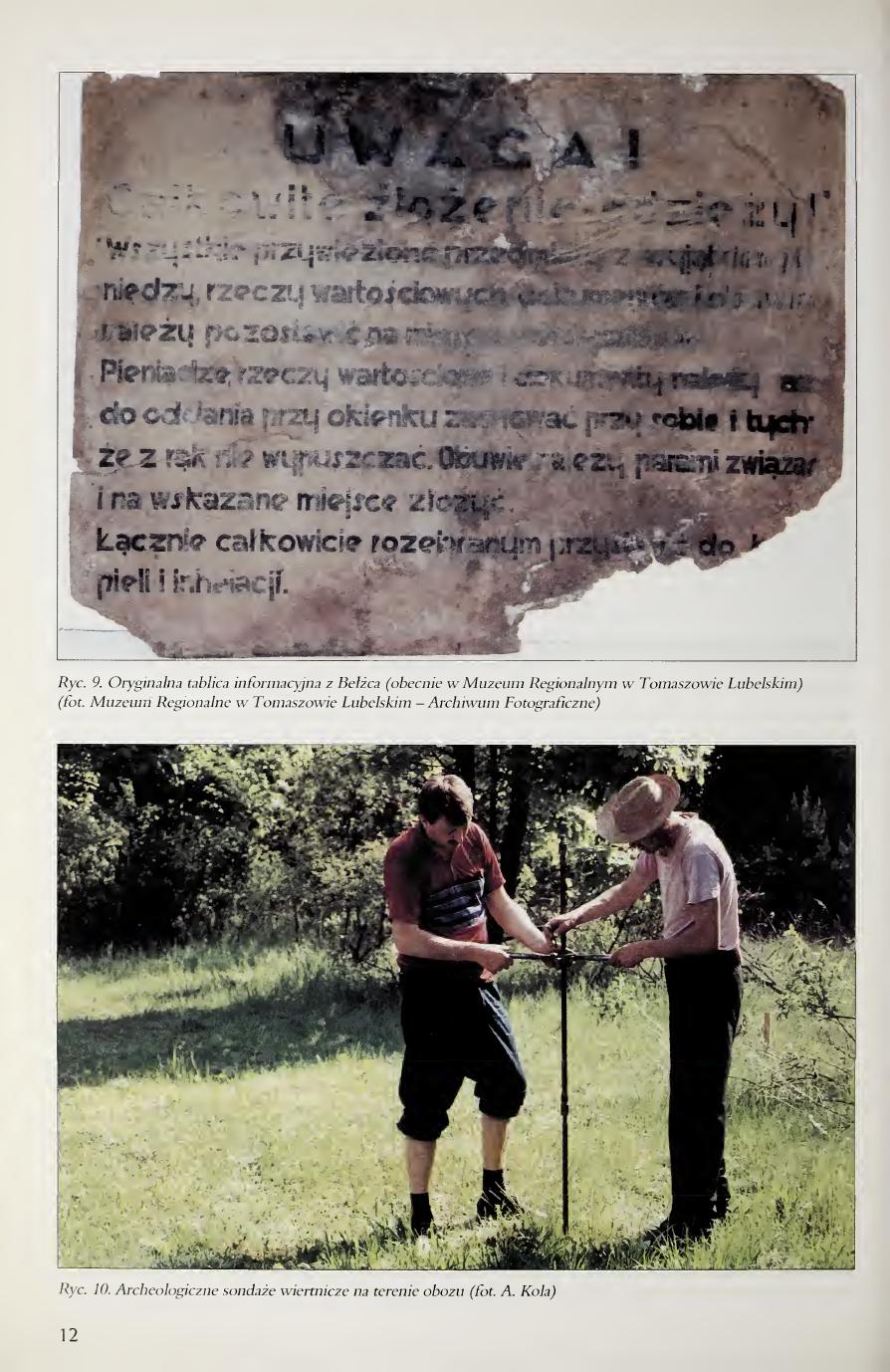
The basic scope of the survey investigations was carried out using hand-held augers (fig. 10) used in geomorphological and archaeological investigations, with a bit-pen diameter of 2.5 inches (ca. 65 mm), with the possibility of penetration in the ground to a depth of about 6.00-8.00 m, which proved to be entirely sufficient in investigations of the earthen relict structures of the camp. The suitability of such an auger for locating mass graves was confirmed in recent years in archaeological-exhumation work at the cemeteries of officers of the Polish Army murdered in spring 1940 by the NKVD, in the framework of investigations connected with the so-called "Katyń [continued next page]
10 A. and S. Skibiński, Badania materiałoznawcze próbek z terenu byłego hitlerowskiego obozu zagłady w Bełżcu. Raport nr 1/98 arch., Toruń 1998, typescript in the Archive of the Council OPWiM.
11 In the Regional Museum in Tomaszów Lubelski there is an original sign (formerly found at Bełżec) with information for the Jews brought to the camp, of the following content: Attention! Complete depositing of clothing! All brought-in items, with the exception of money, valuables, documents, and identification papers, are to be left on the ground (...). Money, valuables, and documents are to be kept on one's person until handing them in at the window, and these are not to be released from one's hands. Footwear is to be tied in pairs and placed at the indicated location. Together completely undressed, proceed to the bath and inhalation (fig. 9). Detailed information about the technique of extermination applied at Bełżec is contained in the account of Kurt Gerstein (1905-1945), SS Obersturmführer, given on 4 May 1945. Gerstein was a witness to the killing of Jews during a visit to this camp on 19 August 1942. Cf.: Europa unterm Hakenkreuz. Die Okkupationspolitik des deutschen Faschismus (1938-1945). Achtbändige Dokumentation. Hrsg. v. einem Kollegium unter Leitung v. Wolfgang Schumann und Ludwig Nestler. Bd. 2: Die faschistische Okkupationspolitik in Polen (1939-1945). Dokumentauswahl und Einleitung von Werner Röhr, East Berlin 1989, pp. 230-233; cf. also: Mord an den Juden, Wochenschau II, Nr. 5, September/October 1996, pp. 190-191.
12 For the purposes of the present investigations, a copy of the situational-elevation map of this area was made available from the Communal Office in Bełżec; sheet 27, Lublin voivodeship, Tomaszów Lub. district, Bełżec gromada, Bełżec supra-gromadal center. Map obtained from the Voivodeship Office in Zamość, Department of Geodesy, Voivodeship Center for Geodesic and Cartographic Documentation, Branch in Tomaszów Lub., Dz. 124/95, ev. no. 157.333-6/81 of 8 February 1995.
13 Within particular hectares, the numbering of ars was adopted in the orderly arrangement of successive ar-strips running from N to S, with successive ars in these strips marked from W to E. The point localization of particular drilling surveys on the map was indicated in the descriptive documentation of the investigations by coordinates according to the schema: successive number of the borehole, number of the hectare marked on the map, and distance in meters from the N boundary of the hectare in the southern direction and distance in meters from the W boundary of the hectare in the eastern direction.
[Page 12]
Page 12 of the book (figures only, no body text on this page). Fig. 9, the original information sign from Bełżec, now in the Regional Museum in Tomaszów Lubelski (photo Regional Museum in Tomaszów Lubelski Photographic Archive). The Polish text on the sign is reproduced in footnote 11 above. Fig. 10, archaeological drilling surveys on the area of the camp (photo A. Kola).
[Page 13]
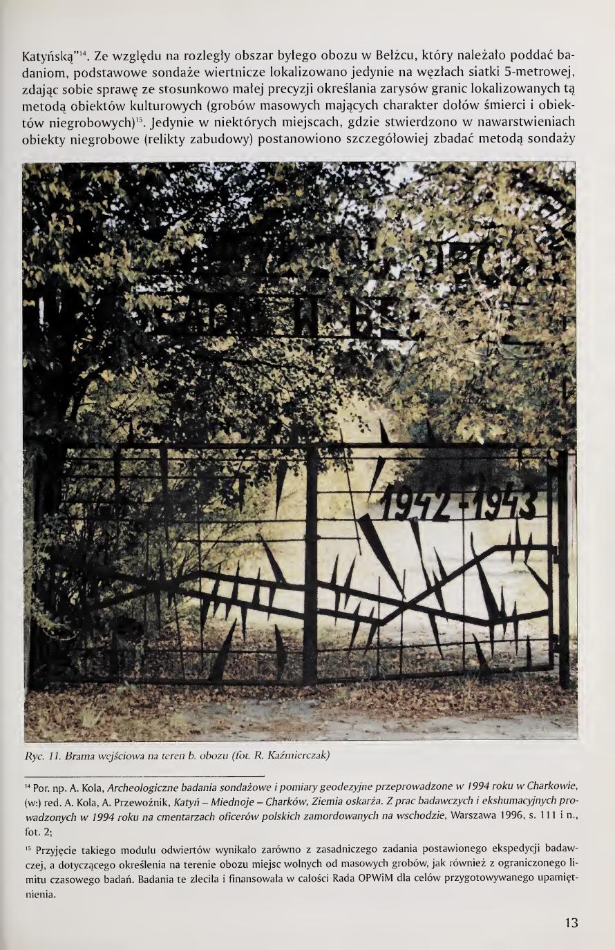
Crime"14. In view of the extensive area of the former camp at Bełżec which had to be subjected to investigations, basic drilling surveys were located only at the nodes of a 5-meter grid, being aware of the relatively low precision of determining by this method the outlines of the boundaries of localized cultural objects (mass graves having the character of death pits and non-grave objects)15. Only in certain places, where non-grave objects (relicts of construction) were found in the strata, was it decided to investigate in more detail by the method of narrow-area surveys [continued next page]
Page 13 of the book. Fig. 11. Entrance gate to the area of the former camp (photo R. Kaźmierczak).
14 Cf. e.g. A. Kola, Archeologiczne badania sondażowe i pomiary geodezyjne przeprowadzone w 1994 roku w Charkowie, in: A. Kola, A. Przewoźnik (eds.), Katyń – Miednoje – Charków, Ziemia oskarża. Z prac badawczych i ekshumacyjnych prowadzonych w 1994 roku na cmentarzach oficerów polskich zamordowanych na wschodzie, Warsaw 1996, p. 111 ff., photo 2.
15 The adoption of such a borehole module followed both from the basic task set for the research expedition, concerning the determination on the camp area of places free of mass graves, as well as from the limited time-budget of the investigations. These investigations were commissioned and financed in their entirety by the Council OPWiM for the purposes of the prepared commemoration.
[Page 14]
narrow-area trenches; boreholes were densified (every 2.00 or every 1.00 m). In total, on the investigated site over the course of two research seasons in 1997 and 1998, 2,227 research boreholes were carried out (see plan p. 70), of which 404 in 1997 and 1,823 in 1998. In 1999, investigations by the method of drilling surveys were no longer carried out. In total, surveys covered the entire area of the camp fenced off in the 1960s, with research boreholes also located beyond this extent: most in the southwestern and southern parts of the investigated site, and to a lesser degree in its eastern part. The boreholes were fully realized in the southern and southwestern parts of the camp, where one was to expect relict structures of camp objects connected with the functioning of the railway ramp and the buildings intended for receiving transports. In this region several narrow-area survey trenches were also carried out for verifying the presumed strip of the course of the railway siding existing within the camp.
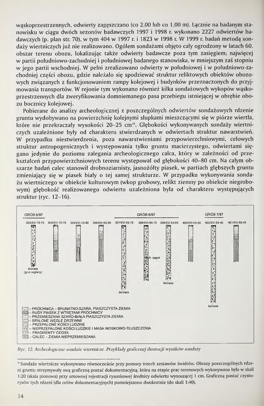
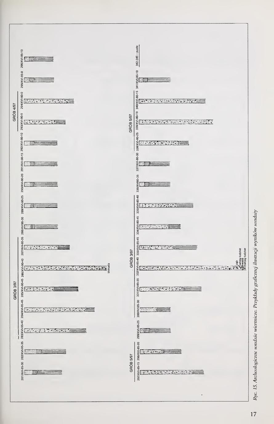
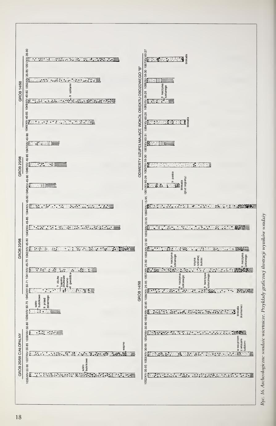
The soil cores taken for archaeological analysis from individual survey boreholes were extracted to the surface in successive cylindrical sections fitting within the bit-pen of the auger, which did not exceed a height of 20-25 cm16. The depths of the drilling surveys carried out depended on the character of the strata structures encountered in the boreholes. In the case of failure to encounter, beyond the near-surface strata, purposeful anthropogenic structures and the occurrence only of the parent ground, the boreholes reached only to the level of the lying of the archaeological subsoil (calec), which depending on the near-surface transformations of the area occurred from a depth of 40-80 cm. Across the entire area of investigations the subsoil consisted of fine-grained, light-yellow sand, in deeper parts of the ground changing to white sand of the same structure. In the case of carrying out a drilling survey in a cultural object (grave pit, earthen relict of a non-grave object) the depth of the realized borehole depended on the character of the structures occurring (figs. 12-16).
Page 14 of the book. Fig. 12. Archaeological drilling surveys, examples of graphic illustration of survey results. Borehole-section graphics for Graves 6/97 and 7/97 with coordinate labels (borehole no. / hectare XVI / N-offset / W-offset). Legend: humus / brown-grey sandy earth; rusty sand with humus inclusions; mixed grey-white sandy earth; burnt charcoal; burnt human bones; unburnt human bones and waxy-fatty mass (adipocere); brick fragments; subsoil, undisturbed earth.
16 Drilling surveys were carried out simultaneously with three sets of augers. The images of individual soil cores received their graphic documentary form, which at the stage of fieldwork was made at scale 1:20 (vertical scale) with a conventional drawing-registration of borehole diameter of 1 cm. The graphic form of the clean drawings of these cores (for documentation purposes) was reduced twofold (to scale 1:40).
[Page 15]
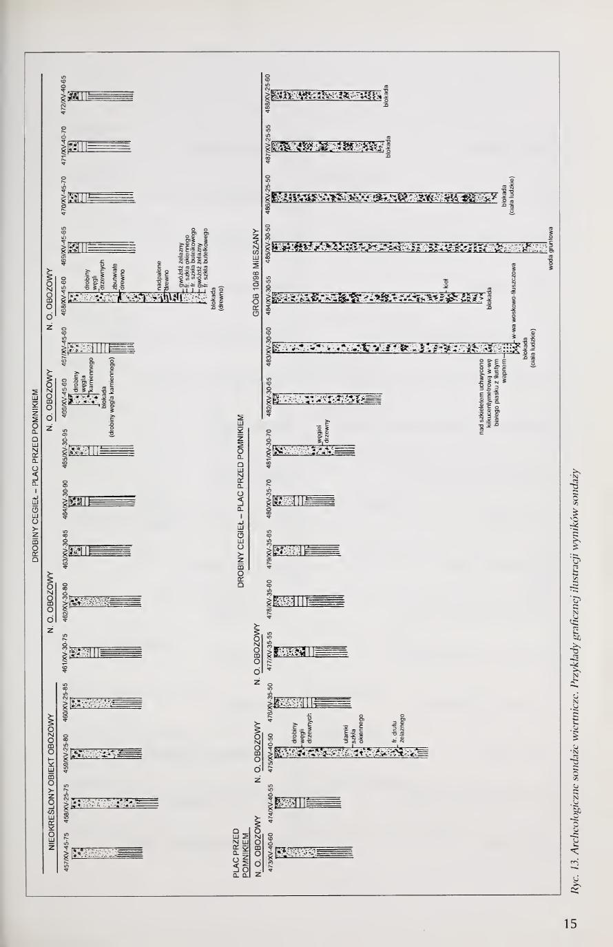
Page 15 of the book (full-page figure plate, no body text). Fig. 13. Archaeological drilling surveys, examples of graphic illustration of survey results. The plate shows borehole-section stratigraphy including a Grave 10/98 column with the legend MIESZANY (mixed strata).
[Page 16]
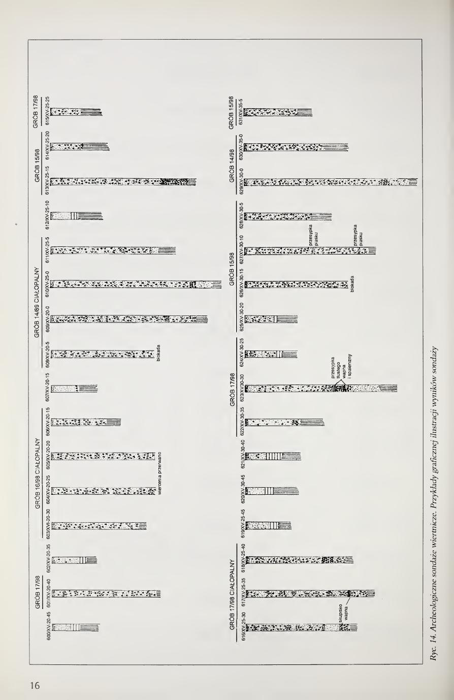
Page 16 of the book (full-page figure plate, no body text). Fig. 14. Archaeological drilling surveys, examples of graphic illustration of survey results.
[Page 17]
Page 17 of the book (full-page figure plate, no body text). Fig. 15. Archaeological drilling surveys, examples of graphic illustration of survey results.
[Page 18]
Page 18 of the book (full-page figure plate, no body text). Fig. 16. Archaeological drilling surveys, examples of graphic illustration of survey results.
[Page 19]
In cases of boreholes carried out in grave structures, these surveys were conducted down to the layers of corpses encountered repeatedly here, lying most commonly at depths from about 3.50 m. As is clear from the analysis of the cross-section profiles of grave pits, in many cases the grave pits reached depths of 4.50-5.00 m, descending even to the groundwater present at these depths. The lying of corpses in the water-bearing layer, or in a strongly water-saturated soil structure above this layer, with restricted air access caused by such considerable burial depth, led to the transformation of the corpses lying here into a wax-fat [continued next page]
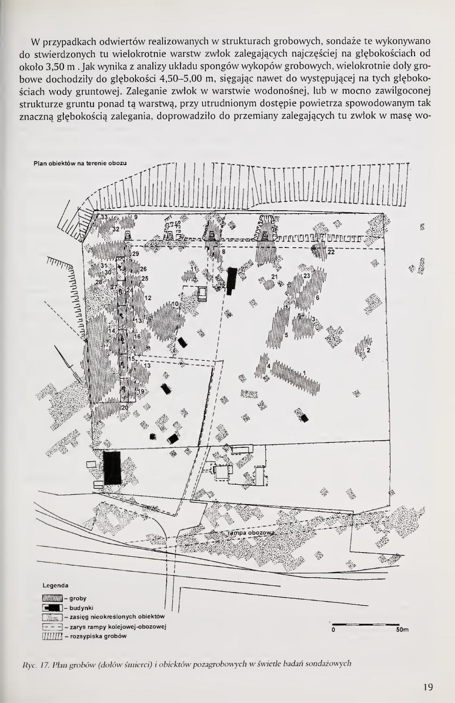
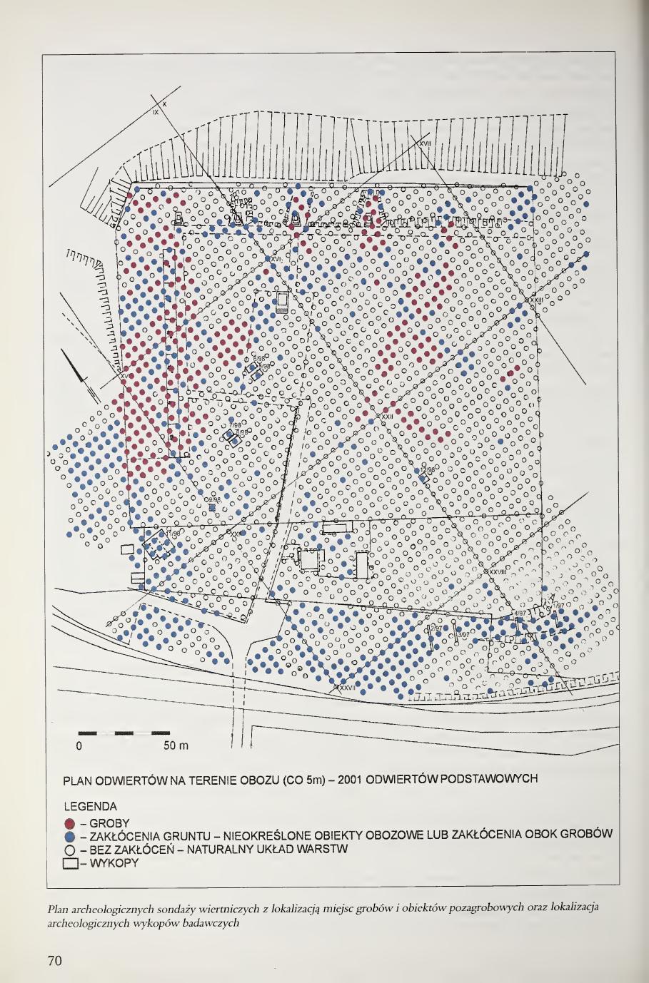
Page 19 of the book. Fig. 17. Plan of the graves (death pits) and non-grave objects on the area of the camp in the light of the survey investigations. Legend: groby = graves; budynki = buildings; zasięg nieokreślonych obiektów = extent of indeterminate objects; zarys rampy kolejowej-obozowej = outline of the camp railway ramp; rozsypiska grobów = grave scatters/spillages. Scale bar: 50 m.
[Page 20]
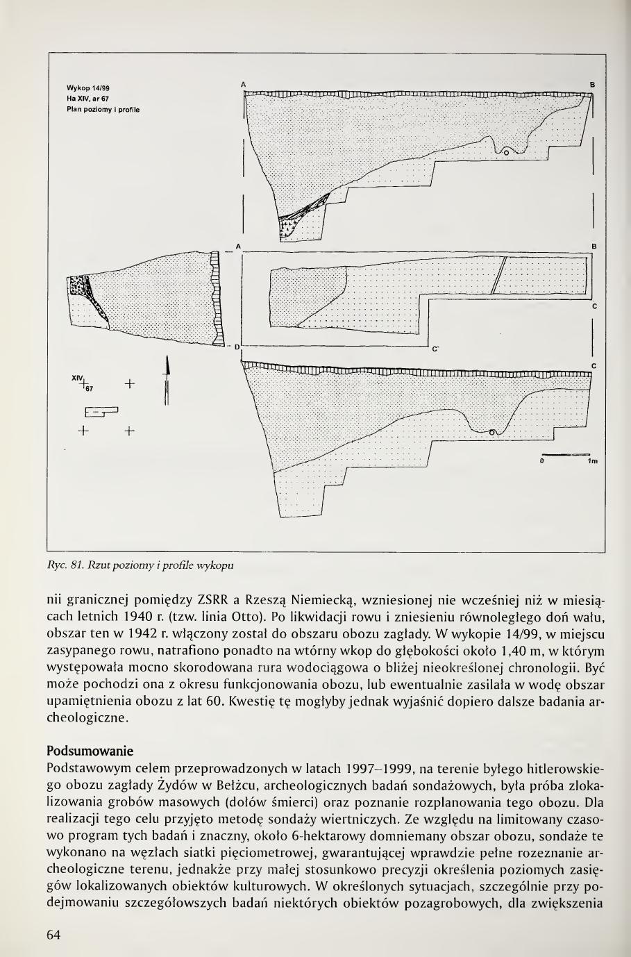
mass17. In some grave pits the layer of corpses reached a thickness of up to ca. 2.00 m. As a rule, in the strata lying above the corpse layer in the grave pits, traces of burnt bone fragments were found, often mixed with charcoal. This fact can be explained by the use of grave-pit basins formed as a result of the compression of corpses for placing in them the residues of cremation hearths from burnt corpses, or by the burning of corpses directly in the pits. The burning of the corpses of victims murdered at Bełżec in the second phase of the camp's functioning is reported by the results of the prosecutorial inquiry conducted in 1945. Some of the grave pits, particularly those of relatively smaller surface area and lesser depth, are exclusively cremation in character. Interlayering of cremation strata and sand was found in them, attesting to the multi-phase filling of the pit with portions of cremation residues from burnt corpses, each time covered with a sandy layer. It must be supposed that often the cremation residues were placed in the grave pits up to the complete filling of their volume, in many cases covering the pits with only a thin surface layer of soil. As a result, during the liquidation of the camp in 1943 and the leveling work then carried out, as well as as a result of the plundering excavations of the camp area immediately after World War II, a significant part of the disturbed soil containing cremation residues found itself on the surface, and even now its traces are legible in the surface structures of the strata, particularly in the western and northern parts of the camp. In these regions of the investigated area the zone of occurrence of grave pits was localized.
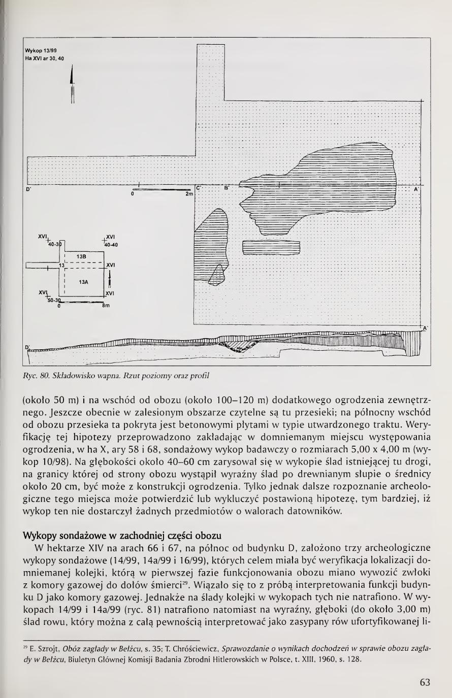
In a significant number of drilling surveys carried out on the area of the former extermination camp for Jews at Bełżec, cultural strata of non-grave character were found (fig. 17). The structure of these strata, as well as their thickness and cultural content, is strongly varied. Generally it can be accepted that these structures represent the remains of various objects of the camp construction, originally more or less recessed into the ground. These objects, at least in their above-surface parts, were completely dismantled in the course of the liquidation of the camp in 1943 and of the deliberate erasure of its traces. The majority of them in the planigraphy of the camp were concentrated outside the zone of grave pits, chiefly in its southern, southwestern, and central parts. A part of the stratigraphic strata, however, not representing relicts of grave structures, occurred in the region of the death pits, and their character could be explained only after the conduct in these places of detailed wide-area archaeological investigations. To this category of archaeological objects (non-grave) should also be added the course of the railway siding in the southern part of the camp, localized on the basis of the analysis of aerial photographs, supported by analysis of the topography of the area. Verification of this localization, as well as an attempt at clarifying the function of several non-grave objects localized in the central part of the camp, was undertaken on the ground of applying here the archaeological method of narrow-area surveys. Within the framework of a narrow-area survey trench, verification was also carried out of the hypothesis of the occurrence north of the camp of the line of a second outer fence.
17 The wax-fat transformation (adipocere) of corpses was found during the exhumation of mass graves of Polish citizens at Mednoye (Russia) and Kharkov (Ukraine), imprisoned at Ostashkov and Starobielsk, murdered in spring 1940 by the NKVD at Kalinin (Tver) and Kharkov. The cause of such transformation of the corpses there was rainwater, which got into the grave pits made in clayey, impermeable soil, seeping to the bottom of the grave pit at places of disturbed fill. The character of the soil caused that at Mednoye and Kharkov the corpses in wax-fat transformation lay already from a depth of ca. 1.50 m; E. Baran, R. Mądro, B. Młodziejowski, Badania sądowo-lekarskie przeprowadzone w ramach ekshumacji w Charkowie i w Miednoje, in: M. Tarczyński (ed.), Zbrodnia Katyńska. Droga do prawdy, Zeszyty Katyńskie no. 2, Warsaw 1992, p. 264; A. Kola, Archeologiczne badania sondażowe i pomiary geodezyjne przeprowadzone w 1994 roku w Charkowie, p. 126.
[Page 21]
Death pits of the Bełżec camp
Among the total of 2,227 archaeological drilling surveys carried out at Bełżec in 1997-98 (fig. 11), in 225 grave structures were encountered in the form of layers of corpses in wax-fat transformation, or such death pits as contained burnt human remains in the form of small, not fully burned bones, with the remains of charcoal probably coming from hearths on which the corpses were burned18. Although the 5-meter module of distance between these boreholes applied in these investigations does not permit precise determination of the extents of the death pits found here, in the light of planigraphic analysis it is preliminarily possible to delineate their approximate localizations and dimensions, and from the analysis of the strata structures registered in the boreholes one can infer the character of the fillings of individual death pits, the forms of the grave pits, and the depth at which they lie19.
Death pit no. 1 (fig. 18)
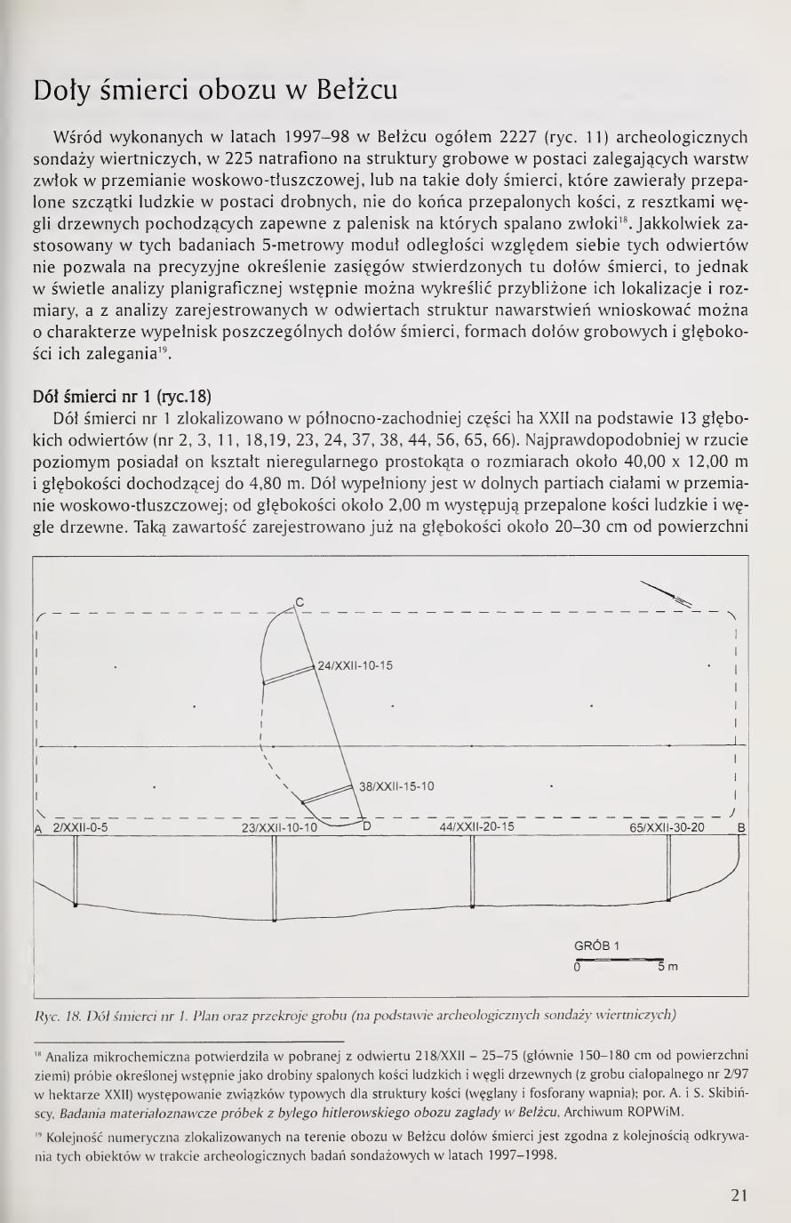
Death pit no. 1 was localized in the northwestern part of hectare XXII on the basis of 13 deep boreholes (nos. 2, 3, 11, 18, 19, 23, 24, 37, 38, 44, 56, 65, 66). Most probably in horizontal projection it had the shape of an irregular rectangle of dimensions about 40.00 × 12.00 m and a depth reaching 4.80 m. The pit is filled in its lower parts with bodies in wax-fat transformation; from a depth of about 2.00 m there occur burnt human bones and charcoal. Such content was registered already at a depth of about 20-30 cm from the [continued next page]
Page 21 of the book. Section opening "Doły śmierci obozu w Bełżcu" (Death pits of the Bełżec camp). Fig. 18. Death pit no. 1, plan and cross-sections of the grave (on the basis of archaeological drilling surveys).
18 Microchemical analysis confirmed in the sample taken from borehole 218/XXII-25-75 (mainly 150-180 cm from the ground surface), preliminarily defined as small particles of burnt human bones and charcoal (from cremation grave no. 2/97 in hectare XXII), the occurrence of compounds typical for bone structure (calcium carbonates and phosphates); cf. A. and S. Skibiński, Badania materiałoznawcze próbek z byłego hitlerowskiego obozu zagłady w Bełżcu, Archive ROPWiM.
19 The numerical sequence of the death pits localized on the area of the camp at Bełżec corresponds to the order of discovery of these objects in the course of the archaeological survey investigations of 1997-1998.
[Page 22]
ground surface. Burnt bones and charcoal also occur in the boreholes surrounding this death pit. In borehole no. 66, in addition to human remains, at a depth of 1.40 m a concentration of refuse was encountered (glass, sheet metal), and at a depth of 1.70 m drilling was discontinued. At a depth of 4.10 m subsurface water appeared. Estimated volume of the pit: about 1,500 m³.
Death pit no. 2 (fig. 19)
It was distinguished in the northeastern part of hectare XXII on the basis of 3 boreholes (nos. 218-220). In the vicinity of this pit considerable disturbances of the soil of unclear genesis occurred. It reaches dimensions of about 14.00 × 6.00 m, descending to a depth of 2.00 m. Cremation grave of volume about 170 m³.
Death pit no. 3 (fig. 20)
It was distinguished in the southern part of hectare XVI on the basis of 9 deep boreholes (nos. 283-287, 331-333, 335). In horizontal projection it has a shape close to a square of dimensions [continued next page]
Page 22 of the book. Fig. 19. Death pit no. 2, plan and cross-sections. Fig. 20. Death pit no. 3, plan and cross-sections.
[Page 23]
16.00 × 15.00 m, reaching a depth of over 5.00 m. At a depth of 4.80 m subsurface water occurred. The content of the pit fill is mixed; from about 20 cm from the surface to a depth of about 4.00 m there is cremation residue mixed with charcoal; below, a layer of corpses in wax-fat transformation. At a depth of ca. 4.00 m drilling was discontinued. Around the pit a scatter of cremation residues was found. The capacity of the pit is about 960 m³.
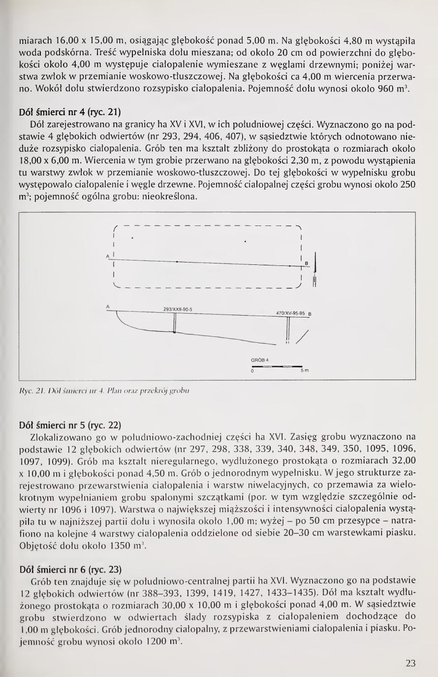
Death pit no. 4 (fig. 21)
The pit was registered on the boundary of hectares XV and XVI, in their southern part. It was determined on the basis of 4 deep boreholes (nos. 293, 294, 406, 407), in the vicinity of which a small scatter of cremation residue was noted. This grave has a shape close to a rectangle of dimensions about 18.00 × 6.00 m. Drilling in this grave was discontinued at a depth of 2.30 m due to the occurrence here of a layer of corpses in wax-fat transformation. To this depth, in the fill of the grave, cremation residue and charcoal occurred. The capacity of the cremation part of the grave is about 250 m³; total capacity of the grave: undetermined.
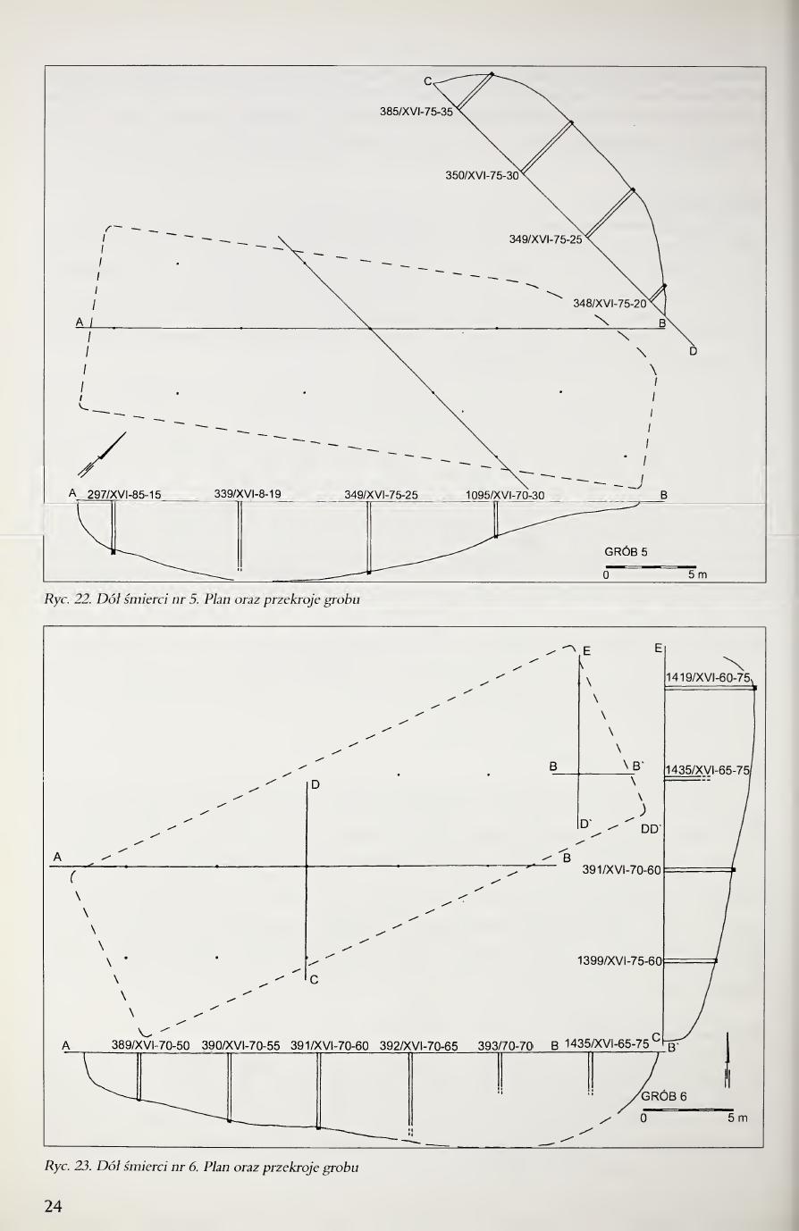
Death pit no. 5 (fig. 22)
It was localized in the southwestern part of hectare XVI. The extent of the grave was determined on the basis of 12 deep boreholes (nos. 297, 298, 338, 339, 340, 348, 349, 350, 1095, 1096, 1097, 1099). The grave has the shape of an irregular elongated rectangle of dimensions 32.00 × 10.00 m and depth over 4.50 m. The grave has a homogeneous fill. In its structure interlayerings of cremation residues and leveling layers were registered, which speaks for repeated filling of the grave with burnt remains (cf. in this regard particularly boreholes nos. 1096 and 1097). The layer of greatest thickness and intensity of cremation residue occurred here in the lowest part of the pit and amounted to about 1.00 m; higher, after a 50 cm covering layer, a further 4 layers of cremation residue were encountered, separated from each other by 20-30 cm sand layers. Volume of the pit about 1,350 m³.
Death pit no. 6 (fig. 23)
This grave is located in the south-central part of hectare XVI. It was determined on the basis of 12 deep boreholes (nos. 388-393, 1399, 1419, 1427, 1433-1435). The pit has the shape of an elongated rectangle of dimensions 30.00 × 10.00 m and depth over 4.00 m. In the vicinity of the grave, in boreholes, traces of a scatter with cremation residue reaching to 1.00 m depth were found. Homogeneous cremation grave, with interlayerings of cremation residue and sand. Capacity of the grave is about 1,200 m³.
Page 23 of the book. Body text on Pits 3 (continued), 4, 5, 6, with embedded Fig. 21 (Pit 4 plan and cross-sections). Figs. 22 and 23 (Pits 5 and 6) follow on page 24.
[Page 24]
Page 24 of the book (full-page figure plate, no body text). Fig. 22. Death pit no. 5, plan and cross-sections. Fig. 23. Death pit no. 6, plan and cross-sections.
[Page 25]
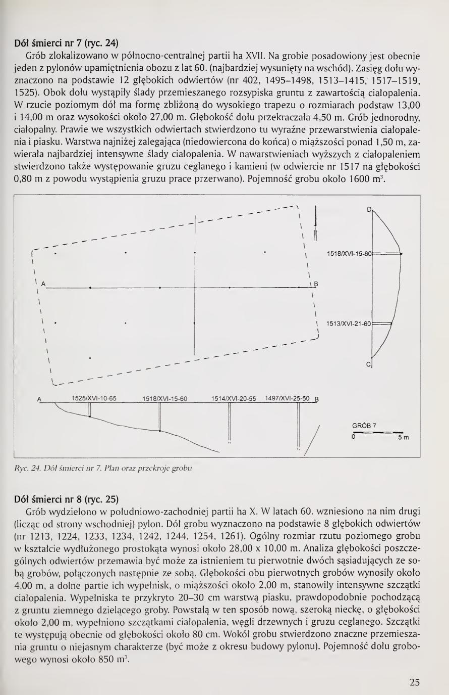
Death pit no. 7 (fig. 24)
The grave was localized in the north-central part of hectare XVII. On the grave there is currently placed one of the pylons of the 1960s commemoration of the camp (the easternmost). The extent of the pit was determined on the basis of 12 deep boreholes (nos. 402, 1495-1498, 1513-1515, 1517-1519, 1525). Adjacent to the pit traces of disturbed soil scatter with cremation residue content occurred. In horizontal projection the pit has a form close to a tall trapezoid with base dimensions of 13.00 and 14.00 m, and a height of about 27.00 m. The depth of the pit exceeded 4.50 m. Homogeneous cremation grave. In nearly all boreholes here distinct interlayerings of cremation residue and sand were found. The lowest layer (not drilled to the bottom), of thickness over 1.50 m, contained the most intensive traces of cremation residue. In the higher strata with cremation residue, the occurrence of brick rubble and stones was also found (in borehole no. 1517 work was discontinued at a depth of 0.80 m due to the occurrence of rubble). Capacity of the grave about 1,600 m³.
Death pit no. 8 (fig. 25)
The grave was distinguished in the southwestern part of hectare X. In the 1960s the second pylon (counting from the east) was erected on it. The pit of the grave was determined on the basis of 8 deep boreholes (nos. 1213, 1224, 1233, 1234, 1242, 1244, 1254, 1261). The general dimensions of the horizontal projection of the grave in the shape of an elongated rectangle are about 28.00 × 10.00 m. Analysis of the depths of individual boreholes argues perhaps for the original existence here of two adjacent graves, subsequently joined together. The depths of both original graves were about 4.00 m, and the lower parts of their fillings, of thickness about 2.00 m, constituted intensive cremation remains. These fillings were covered with a 20-30 cm layer of sand, probably coming from the earth dividing the graves. The new wide depression formed in this way, of depth about 2.00 m, was filled with cremation remains, charcoal, and brick rubble. These remains now occur from a depth of about 80 cm. Around the grave considerable disturbances of soil of unclear character were found (perhaps from the period of the pylon's construction). Capacity of the grave pit is about 850 m³.
Page 25 of the book. Fig. 24. Death pit no. 7, plan and cross-sections. Fig. 25. Death pit no. 8, plan and cross-sections.
[Page 26]
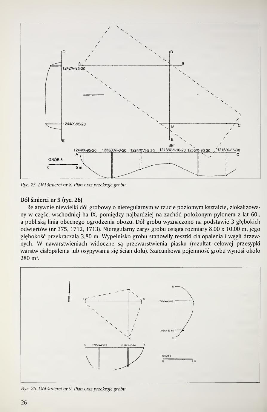
Death pit no. 9 (fig. 26)
A relatively small grave pit of irregular shape in horizontal projection, localized in the eastern part of hectare IX, between the westernmost pylon of the 1960s and the nearby line of the present camp fencing. The pit of the grave was determined on the basis of 3 deep boreholes (nos. 375, 1712, 1713). The irregular outline of the grave reaches dimensions of 8.00 × 10.00 m, its depth exceeded 3.80 m. The fill of the grave consisted of remains of cremation residue and charcoal. In the strata, interlayerings of sand are visible (the result of deliberate covering of cremation layers or of caving of the pit walls). Estimated capacity of the grave is about 280 m³.
Page 26 of the book. Fig. 26. Death pit no. 9, plan and cross-sections.
[Page 27]
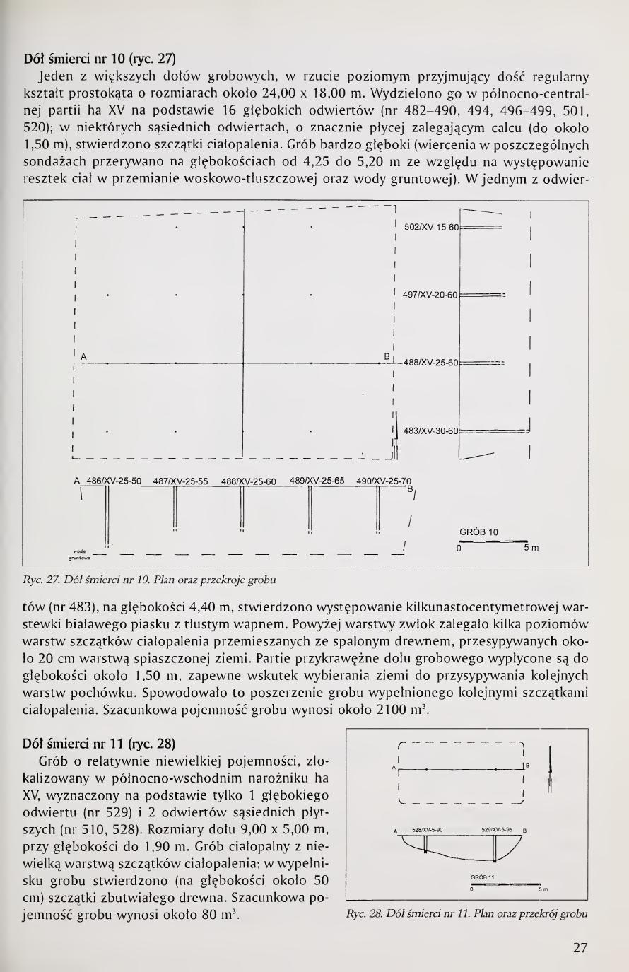
Death pit no. 10 (fig. 27)
One of the larger grave pits, in horizontal projection assuming a fairly regular rectangular shape of dimensions about 24.00 × 18.00 m. It was distinguished in the north-central part of hectare XV on the basis of 16 deep boreholes (nos. 482-490, 494, 496-499, 501, 520); in some neighboring boreholes, with significantly shallower-lying subsoil (up to about 1.50 m), remains of cremation residue were found. Very deep grave (drilling in individual surveys was discontinued at depths from 4.25 to 5.20 m due to the occurrence of remains of corpses in wax-fat transformation, as well as groundwater). In one of the boreholes (no. 483), at a depth of 4.40 m, the occurrence of a layer of whitish sand with greasy lime several centimeters thick was found. Above the layer of corpses lay several levels of cremation remains mixed with burnt wood, covered by about a 20 cm layer of sandy soil. The marginal parts of the grave pit are shallowed to a depth of about 1.50 m, probably as a result of taking earth to cover successive burial layers. This caused the widening of the grave filled with successive cremation remains. Estimated capacity of the grave is about 2,100 m³.
Death pit no. 11 (fig. 28)
A grave of relatively small capacity, localized in the northeastern corner of hectare XV, determined on the basis of only 1 deep borehole (no. 529) and 2 neighboring shallower boreholes (nos. 510, 528). Dimensions of the pit 9.00 × 5.00 m, with depth up to 1.90 m. Cremation grave with a small layer of cremation remains; in the fill of the grave (at a depth of about 50 cm) remains of decayed wood were found. Estimated capacity of the grave is about 80 m³.
Page 27 of the book. Fig. 27. Death pit no. 10, plan and cross-sections (the largest single grave pit at Bełżec, ca. 2,100 m³). Fig. 28. Death pit no. 11, plan and cross-section (the smallest grave pit identified, ca. 80 m³).
[Page 28]
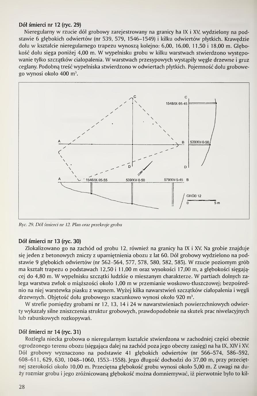
Death pit no. 12 (fig. 29)
An irregular grave pit in projection registered on the boundary of hectares IX and XV, distinguished on the basis of 6 deep boreholes (nos. 539, 579, 1546-1549) and several shallow boreholes. The edges of the pit in the shape of an irregular trapezoid measure successively: 6.00, 16.00, 11.50 and 18.00 m. The depth of the pit reaches below 4.00 m. In the fill of the grave, in several layers, only remains of cremation residue were found. In the covering layers charcoal and brick rubble occurred. Similar fill content was found in the shallow boreholes. Capacity of the grave pit is about 400 m³.
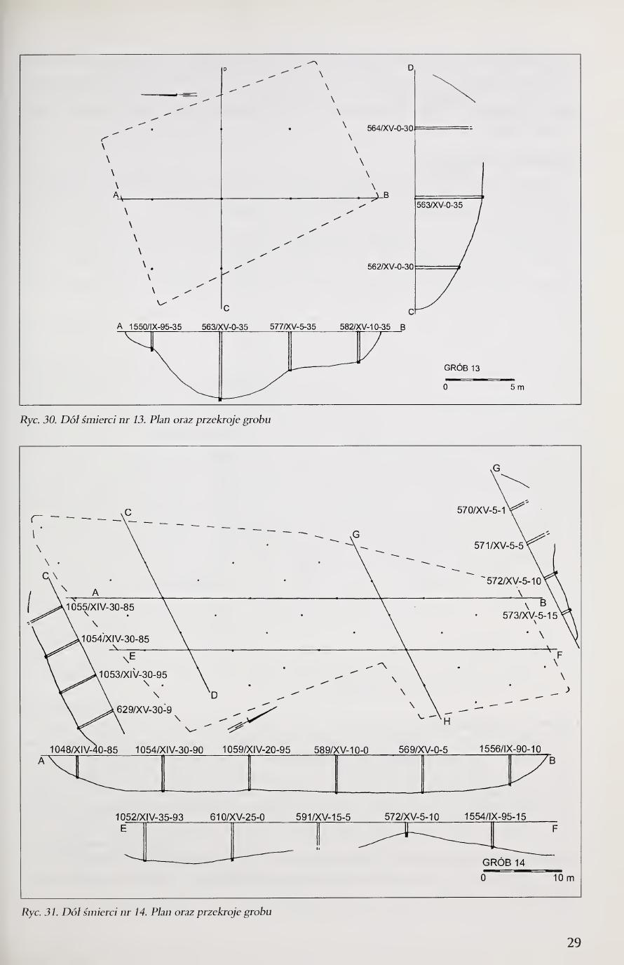
Death pit no. 13 (fig. 30)
It was localized west of grave 12, also on the boundary of hectares IX and XV. On the grave is one of the concrete memorial flames of the 1960s camp commemoration. The grave pit was distinguished on the basis of 9 deep boreholes (nos. 562-564, 577, 578, 580, 582, 585). In horizontal projection the grave has the shape of a trapezoid with bases 12.50 and 11.00 m and height 17.00 m, and depth reaching 4.80 m. In the fill there are human remains of mixed character. In the lower parts lies a layer of corpses about 1.00 m thick in wax-fat transformation; directly upon it a thin layer of sand with lime. Higher, several strata of cremation remains and charcoal. Volume of the grave pit estimated at about 920 m³.
In the zone between graves nos. 12, 13, 14 and 24, in the surface strata, the boreholes showed strong destruction of grave structures, probably as a result of leveling work or plundering excavations.
Death pit no. 14 (fig. 31)
An extensive grave depression of irregular shape, found in the western part of the currently fenced camp area (extending farther west beyond its present extent) in hectares IX, XIV, and XV. The grave pit was determined on the basis of 41 deep boreholes (nos. 566-574, 586-592, 608-611, 629, 630, 1048-1060, 1553-1558). Its length reaches 37.00 m, with an average width of about 10.00 m. The average depth of the grave is about 5.00 m. Given the large size of the grave and its varied depth one may suppose that originally it was sev- [continued next page]
Page 28 of the book. Fig. 29. Death pit no. 12, plan and cross-sections. Fig. 31. Death pit no. 14, plan and cross-sections (this is the largest grave by surface area, in hectares IX, XIV, and XV).
[Page 29]
Page 29 of the book (figure plate, caption only). Fig. 30. Death pit no. 13, plan and cross-sections.
[Page 30]
eral adjacent pits, destroyed in the course of covering with successive strata of cremation remains. In the fill of the grave (in the boreholes) numerous contaminations with various debris (fragments of vessel glass, plastic) were found. Cremation remains occur in the grave already directly under the surface of the ground. Capacity of the grave exceeds 1,850 m³.
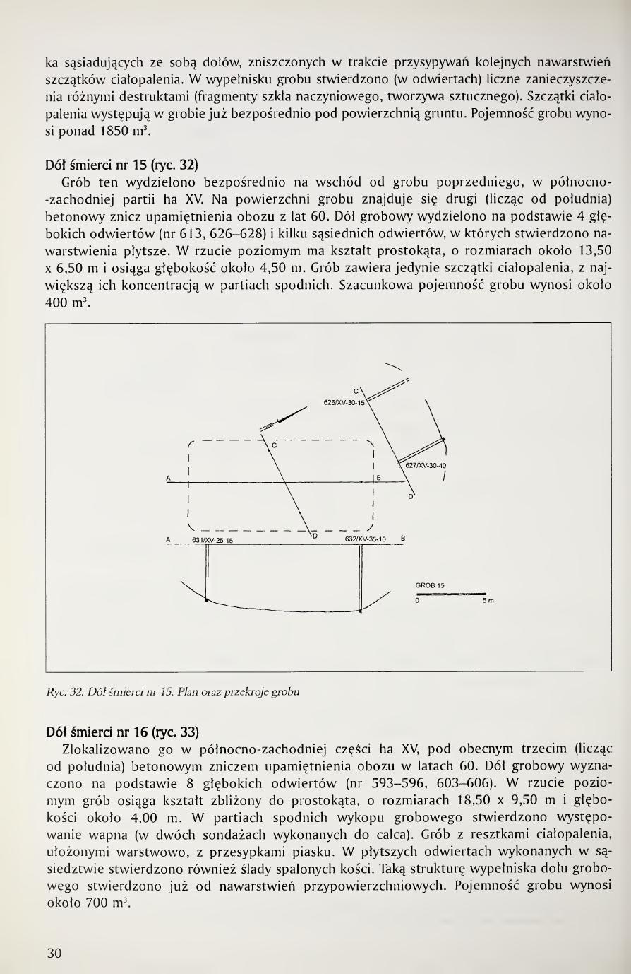
Death pit no. 15 (fig. 32)
This grave was distinguished directly east of the previous grave, in the northwestern part of hectare XV. On the surface of the grave is the second (counting from the south) concrete memorial flame of the 1960s camp commemoration. The grave pit was distinguished on the basis of 4 deep boreholes (nos. 613, 626-628) and several neighboring boreholes in which shallower strata were found. In horizontal projection it has the shape of a rectangle, of dimensions about 13.50 × 6.50 m, and reaches a depth of about 4.50 m. The grave contains only cremation remains, with their greatest concentration in the lower parts. Estimated capacity of the grave is about 400 m³.
Death pit no. 16 (fig. 33)
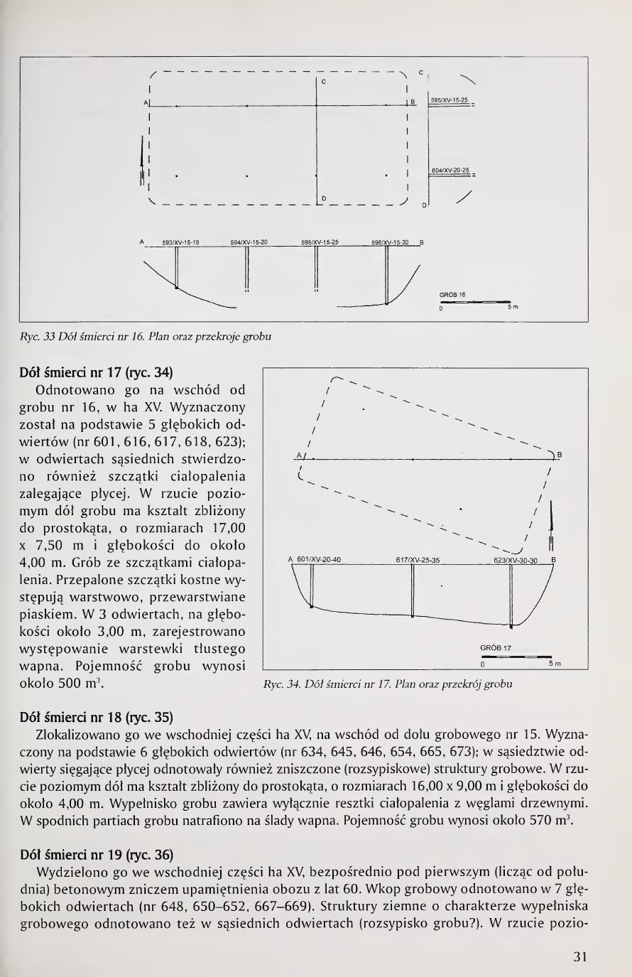
It was localized in the northwestern part of hectare XV, beneath the present third (counting from the south) concrete memorial flame of the 1960s camp commemoration. The grave pit was determined on the basis of 8 deep boreholes (nos. 593-596, 603-606). In horizontal projection the grave reaches a shape close to a rectangle, of dimensions 18.50 × 9.50 m and depth about 4.00 m. In the lower parts of the grave excavation the occurrence of lime was found (in two surveys carried out down to the subsoil). Grave with cremation remains, layered, with sand covering layers. In the shallower boreholes carried out in the vicinity, traces of burnt bones were also found. Such structure of the grave-pit fill was found already from the near-surface strata. Capacity of the grave is about 700 m³.
Page 30 of the book. Fig. 32. Death pit no. 15, plan and cross-sections. Fig. 33. Death pit no. 16, plan and cross-sections.
[Page 31]
Death pit no. 17 (fig. 34)
It was registered east of grave no. 16, in hectare XV. It was determined on the basis of 5 deep boreholes (nos. 601, 616, 617, 618, 623); in neighboring boreholes shallower-lying remains of cremation residue were also found. In horizontal projection the grave pit has a shape close to a rectangle, of dimensions 17.00 × 7.50 m and depth up to about 4.00 m. Grave with cremation remains. Burnt bone fragments occur in layers, interlayered with sand. In 3 boreholes, at a depth of about 3.00 m, a thin layer of greasy lime was registered. Capacity of the grave is about 500 m³.
Death pit no. 18 (fig. 35)
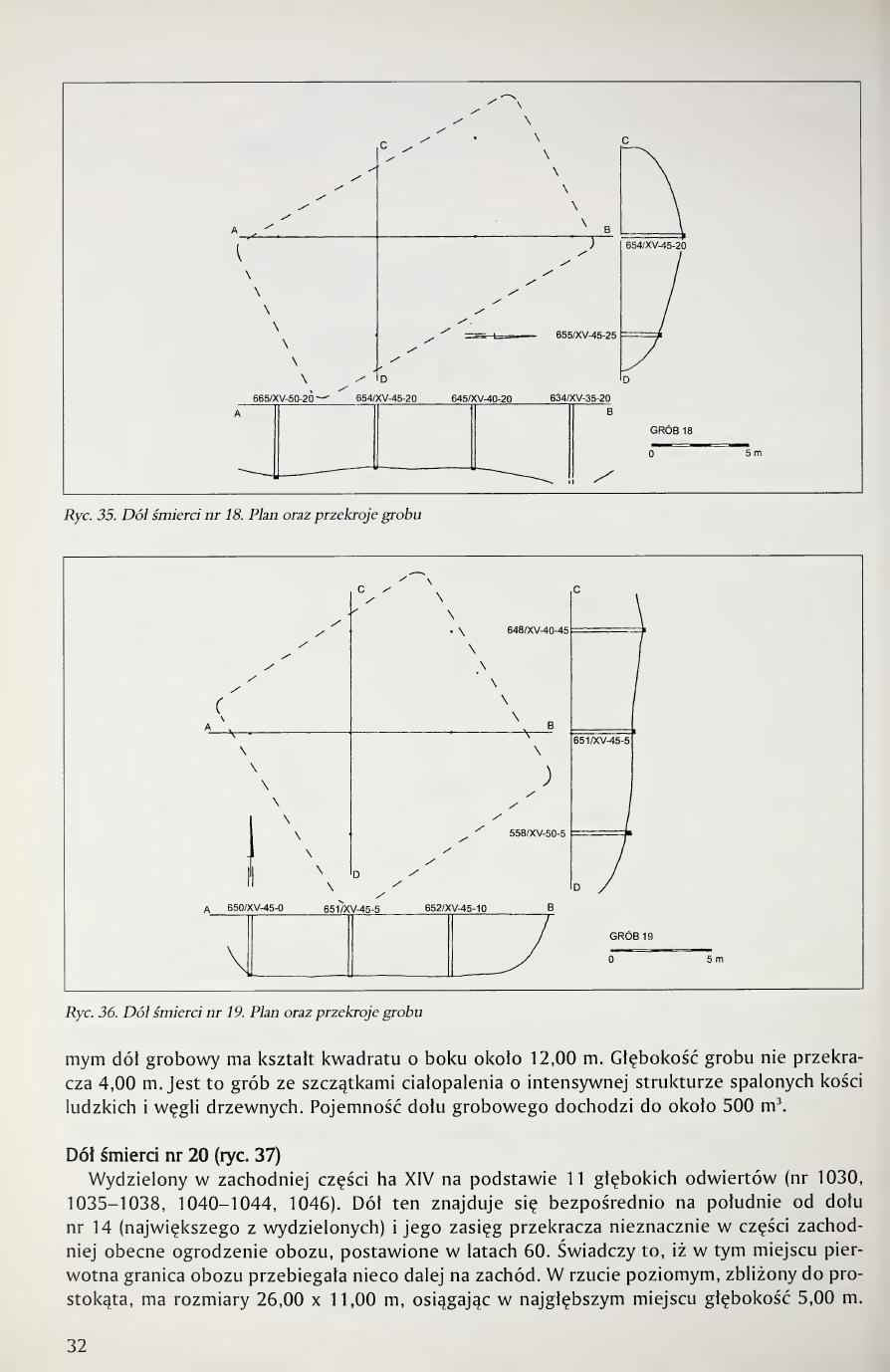
It was localized in the eastern part of hectare XV, east of grave pit no. 15. Determined on the basis of 6 deep boreholes (nos. 634, 645, 646, 654, 665, 673); in the vicinity, shallower-reaching boreholes also registered destroyed (scatter) grave structures. In horizontal projection the pit has a shape close to a rectangle, of dimensions 16.00 × 9.00 m and depth up to about 4.00 m. The grave fill contains exclusively cremation remains with charcoal. In the lower parts of the grave traces of lime were encountered. Capacity of the grave is about 570 m³.
Death pit no. 19 (fig. 36)
It was distinguished in the eastern part of hectare XV, directly beneath the first (counting from the south) concrete memorial flame of the 1960s camp commemoration. The grave excavation was registered in 7 deep boreholes (nos. 648, 650-652, 667-669). Earth structures of the character of grave fill were also registered in adjacent boreholes (grave scatter?). In horizontal projection [continued next page]
Page 31 of the book. Fig. 34. Death pit no. 17, plan and cross-section of the grave.
[Page 32]
Page 32 of the book. Fig. 35 (top). Death pit no. 18, plan and cross-sections. Fig. 36. Death pit no. 19, plan and cross-sections.
the grave pit has the shape of a square with a side of about 12.00 m. The depth of the grave does not exceed 4.00 m. This is a grave with cremation remains, with an intensive structure of burnt human bones and charcoal. The capacity of the grave pit reaches about 500 m³.
Death pit no. 20 (fig. 37)
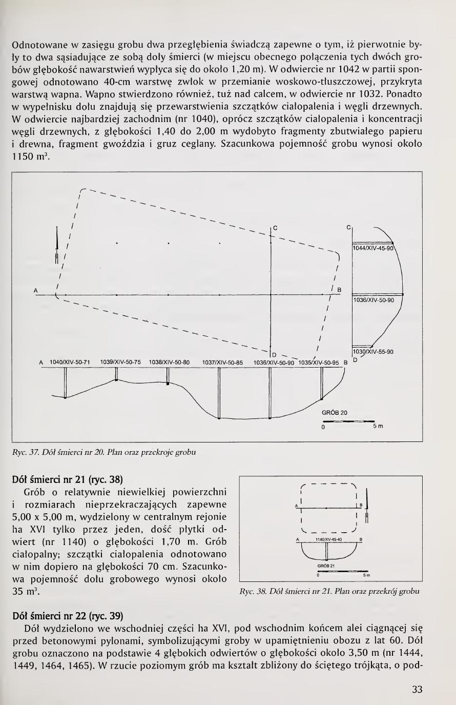
Distinguished in the western part of hectare XIV on the basis of 11 deep boreholes (nos. 1030, 1035-1038, 1040-1044, 1046). This pit lies directly south of pit no. 14 (the largest distinguished) and its extent slightly exceeds, in the western part, the present camp fence erected in the 1960s. This indicates that at this place the original camp boundary ran somewhat farther west. In horizontal projection, close to a rectangle, it has dimensions of 26.00 × 11.00 m, reaching at the deepest place a depth of 5.00 m. [continued next page]
[Page 33]
Two depressions noted within the extent of the grave probably indicate that originally there were two adjacent death pits here (at the place of the present junction of these two graves the depth of the strata becomes shallow to about 1.20 m). In borehole no. 1042 in the lower part a 40-cm layer of corpses in wax-fat transformation was noted, covered by a layer of lime. Lime was also found, just above the subsoil, in borehole no. 1032. Furthermore, in the fill of the pit there are interlayerings of cremation remains and charcoal. In the westernmost borehole (no. 1040), in addition to cremation remains and a concentration of charcoal, fragments of decayed paper and wood, a fragment of a nail, and brick rubble were extracted from a depth of 1.40 to 2.00 m. Estimated capacity of the grave is about 1,150 m³.
Death pit no. 21 (fig. 38)
A grave of relatively small surface area and dimensions probably not exceeding 5.00 × 5.00 m, distinguished in the central region of hectare XVI by only one rather shallow borehole (no. 1140) of 1.70 m depth. Cremation grave; cremation remains were noted in it only at a depth of 70 cm. Estimated capacity of the grave pit is about 35 m³.
Death pit no. 22 (fig. 39)
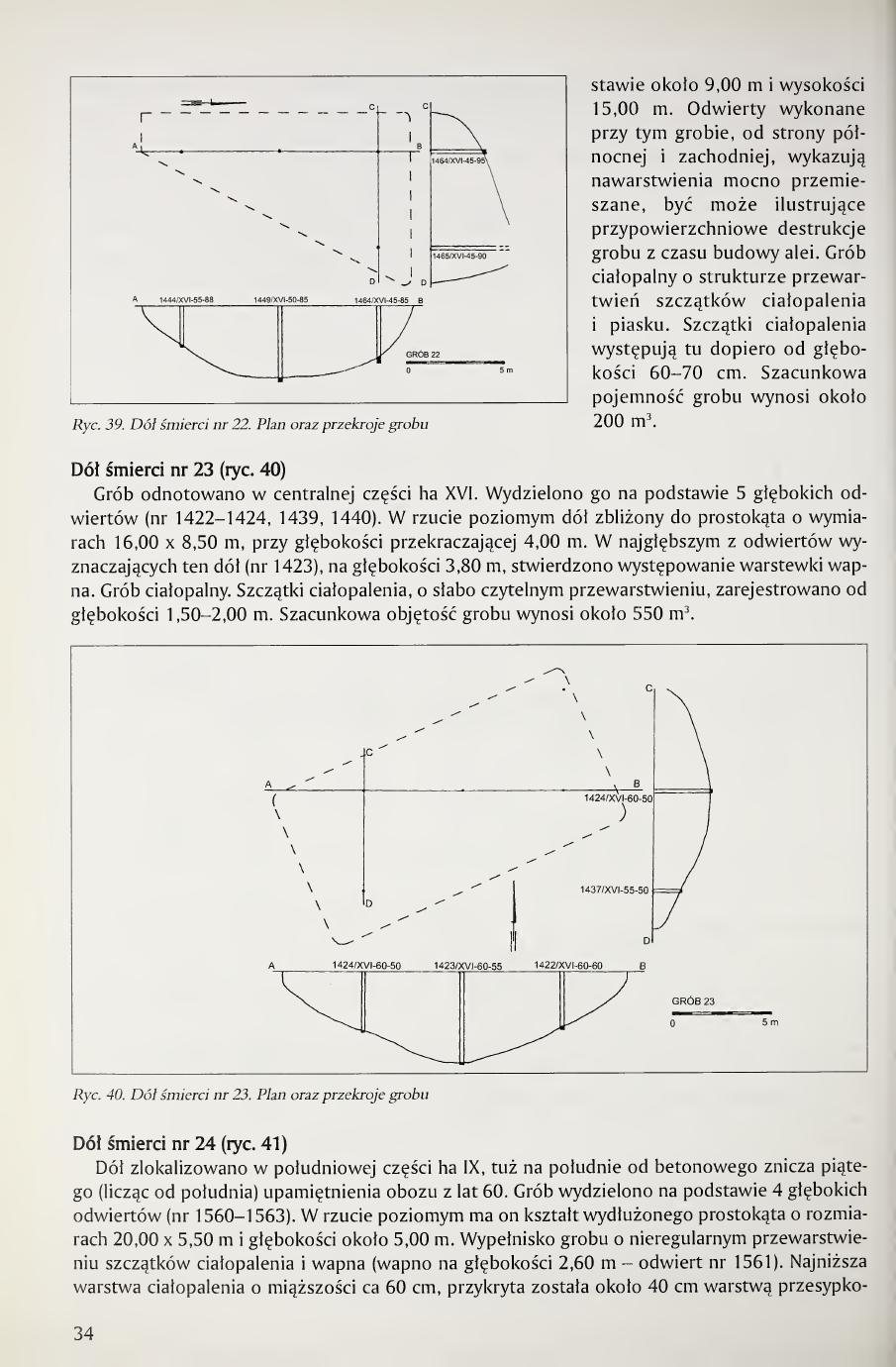
The pit was distinguished in the eastern part of hectare XVI, beneath the eastern end of the avenue running before the concrete pylons symbolizing graves in the 1960s camp commemoration. The pit of the grave was indicated on the basis of 4 deep boreholes of about 3.50 m depth (nos. 1444, 1449, 1464, 1465). In horizontal projection the grave has a shape close to a truncated triangle, with a base [continued next page]
Page 33 of the book. Fig. 37. Death pit no. 20, plan and cross-sections. Fig. 38. Death pit no. 21, plan and cross-section.
[Page 34]
of about 9.00 m and a height of 15.00 m. Boreholes carried out at this grave from the northern and western sides show strongly disturbed strata, perhaps illustrating near-surface destructions of the grave from the time of building the avenue. Cremation grave with structure of interlayerings of cremation remains and sand. Cremation remains occur here only from a depth of 60-70 cm. Estimated capacity of the grave is about 200 m³.
Death pit no. 23 (fig. 40)
The grave was registered in the central part of hectare XVI. It was distinguished on the basis of 5 deep boreholes (nos. 1422-1424, 1439, 1440). In horizontal projection a pit close to a rectangle of dimensions 16.00 × 8.50 m, with depth exceeding 4.00 m. In the deepest of the boreholes determining this pit (no. 1423), at a depth of 3.80 m, the occurrence of a thin layer of lime was found. Cremation grave. Cremation remains, with poorly readable interlayerings, were registered from a depth of 1.50-2.00 m. Estimated volume of the grave is about 550 m³.
Death pit no. 24 (fig. 41)
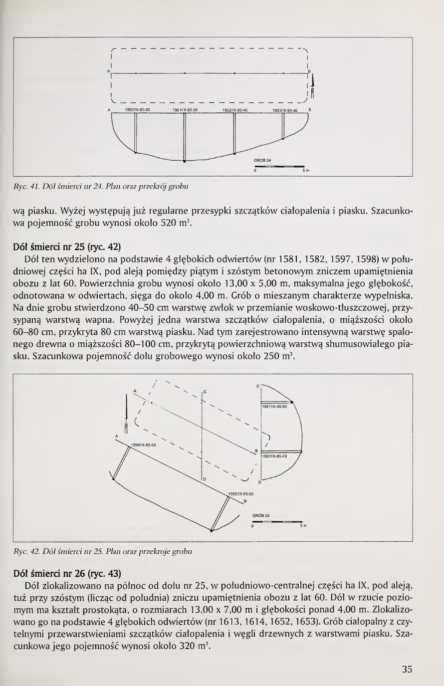
The pit was localized in the southern part of hectare IX, just south of the fifth (counting from the south) concrete memorial flame of the 1960s camp commemoration. The grave was distinguished on the basis of 4 deep boreholes (nos. 1560-1563). In horizontal projection it has the shape of an elongated rectangle of dimensions 20.00 × 5.50 m and depth about 5.00 m. Fill of the grave with irregular interlayering of cremation remains and lime (lime at a depth of 2.60 m, borehole no. 1561). The lowest cremation layer of about 60 cm thickness was covered by a 40 cm covering [continued next page]
Page 34 of the book. Fig. 39. Death pit no. 22, plan and cross-sections. Fig. 40. Death pit no. 23, plan and cross-sections.
[Page 35]
layer of sand. Higher up, regular covering layers of cremation remains and sand already occur. Estimated capacity of the grave is about 520 m³.
Death pit no. 25 (fig. 42)
This pit was distinguished on the basis of 4 deep boreholes (nos. 1581, 1582, 1597, 1598) in the southern part of hectare IX, under the avenue between the fifth and sixth concrete memorial flames of the 1960s camp commemoration. The surface area of the grave is about 13.00 × 5.00 m, its maximum depth, registered in the boreholes, reaches about 4.00 m. Grave of mixed fill character. At the bottom of the grave a 40-50 cm layer of corpses in wax-fat transformation was found, covered with a layer of lime. Above this, one layer of cremation remains, of thickness about 60-80 cm, covered with an 80 cm sand layer. Above this an intensive layer of burnt wood of 80-100 cm thickness was registered, covered with a surface layer of humified sand. Estimated capacity of the grave pit is about 250 m³.
Death pit no. 26 (fig. 43)
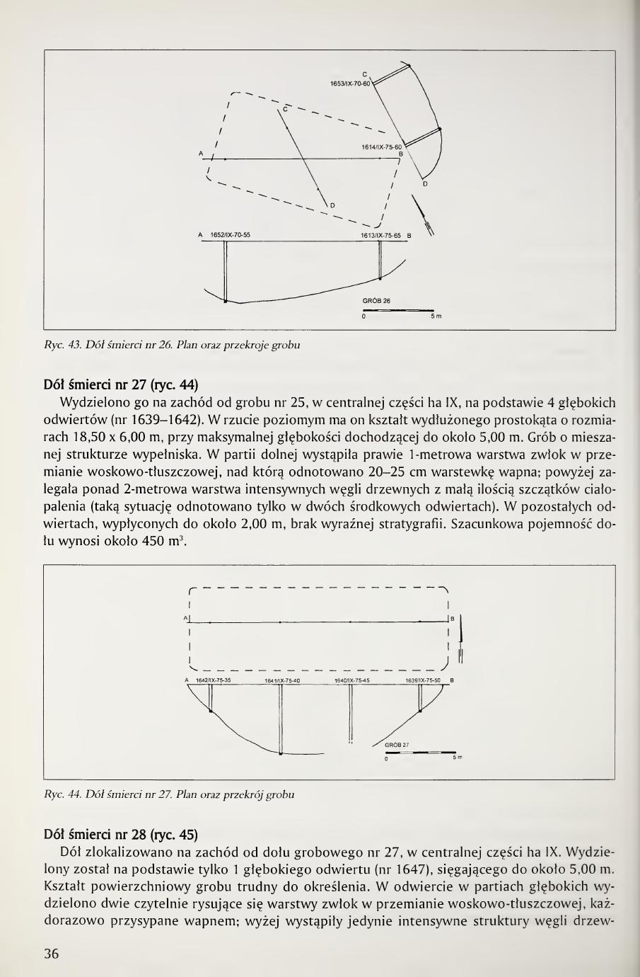
The pit was localized north of pit no. 25, in the south-central part of hectare IX, beneath the avenue, just by the sixth (counting from the south) memorial flame of the 1960s camp commemoration. The pit in horizontal projection has the shape of a rectangle, of dimensions 13.00 × 7.00 m and depth over 4.00 m. It was localized on the basis of 4 deep boreholes (nos. 1613, 1614, 1652, 1653). Cremation grave with readable interlayerings of cremation remains and charcoal with sand layers. Estimated capacity is about 320 m³.
Page 35 of the book. Fig. 41. Death pit no. 24, plan and cross-section. Fig. 42. Death pit no. 25, plan and cross-sections. Fig. 43. Death pit no. 26, plan and cross-sections.
[Page 36]
Death pit no. 27 (fig. 44)
It was distinguished west of grave no. 25, in the central part of hectare IX, on the basis of 4 deep boreholes (nos. 1639-1642). In horizontal projection it has the shape of an elongated rectangle of dimensions 18.50 × 6.00 m, with maximum depth reaching about 5.00 m. Grave of mixed fill structure. In the lower part there occurred an almost 1-meter layer of corpses in wax-fat transformation, above which was registered a 20-25 cm thin layer of lime; higher up lay an over 2-meter layer of intensive charcoal with a small amount of cremation remains (such a situation was registered only in two central boreholes). In the remaining boreholes, shallowed to about 2.00 m, no clear stratigraphy. Estimated capacity of the pit is about 450 m³.
Death pit no. 28 (fig. 45)
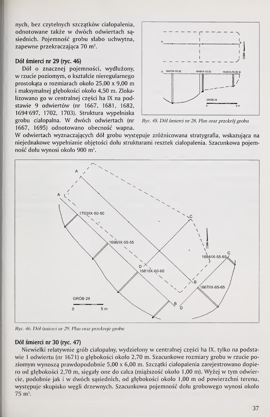
The pit was localized west of grave pit no. 27, in the central part of hectare IX. It was distinguished on the basis of only 1 deep borehole (no. 1647), reaching to about 5.00 m. The surface shape of the grave is difficult to determine. In the borehole, in the deep parts, two clearly delineated layers of corpses in wax-fat transformation were distinguished, each covered with lime; higher up there occurred only intensive structures of charcoal [continued next page]
Page 36 of the book. Fig. 44. Death pit no. 27, plan and cross-section.
[Page 37]
without readable cremation remains, also noted in two adjacent boreholes. The capacity of the grave is poorly graspable, probably exceeding 70 m³.
Death pit no. 29 (fig. 46)
A pit of considerable capacity, elongated in horizontal projection, of irregular rectangular shape of dimensions about 25.00 × 9.00 m and maximum depth about 4.50 m. It was localized in the central part of hectare IX on the basis of 9 boreholes (nos. 1667, 1681, 1682, 1694-1697, 1702, 1703). The structure of the grave fill is cremation. In two boreholes (nos. 1667, 1695) the presence of lime was noted. In the boreholes determining the grave pit, varied stratigraphy occurs, indicating uneven filling of the volume of the pit with structures of cremation remains. Estimated capacity of the pit is about 900 m³.
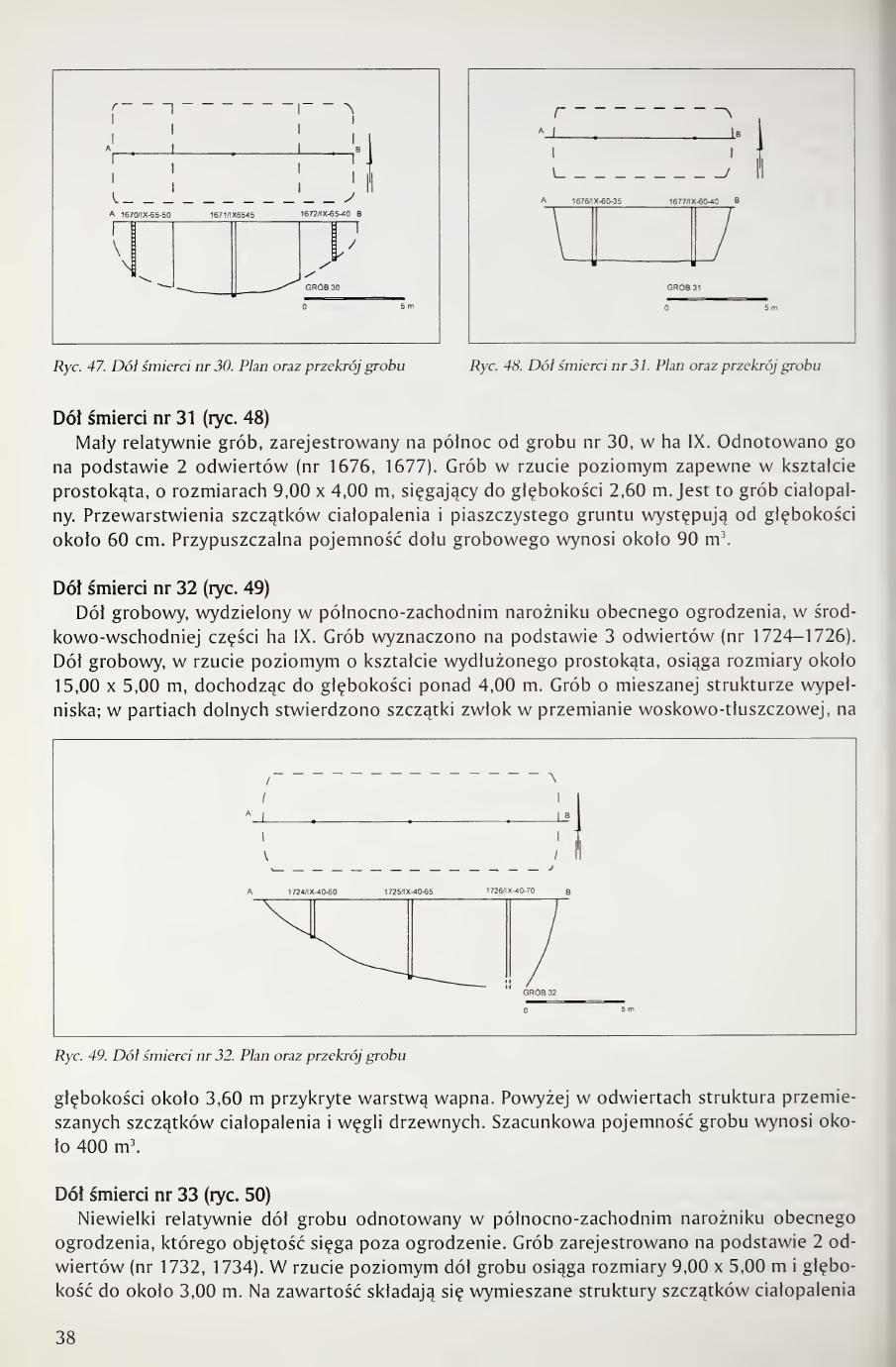
Death pit no. 30 (fig. 47)
A relatively small cremation grave, distinguished in the central part of hectare IX, only on the basis of 1 borehole (no. 1671) of about 2.70 m depth. Estimated dimensions of the grave in horizontal projection are probably 5.00 × 6.00 m. Cremation remains were registered only from a depth of 2.70 m, reaching to the subsoil (thickness about 1.00 m). Higher up in this borehole, similarly as in two adjacent ones, from a depth of about 1.00 m from the surface of the area, a concentration of charcoal occurs. Estimated capacity of the grave pit is about 75 m³.
Page 37 of the book. Fig. 45. Death pit no. 28, plan and cross-section. Fig. 46. Death pit no. 29, plan and cross-sections.
[Page 38]
Death pit no. 31 (fig. 48)
A relatively small grave, registered north of grave no. 30, in hectare IX. Noted on the basis of 2 boreholes (nos. 1676, 1677). Grave in horizontal projection probably in the shape of a rectangle, of dimensions 9.00 × 4.00 m, reaching a depth of 2.60 m. This is a cremation grave. Interlayerings of cremation remains and sandy soil occur from a depth of about 60 cm. Presumed capacity of the grave pit is about 90 m³.
Death pit no. 32 (fig. 49)
A grave pit, distinguished in the northwestern corner of the present fencing, in the central-eastern part of hectare IX. The grave was determined on the basis of 3 boreholes (nos. 1724-1726). The grave pit, in horizontal projection of the shape of an elongated rectangle, reaches dimensions of about 15.00 × 5.00 m, descending to a depth of over 4.00 m. Grave of mixed fill structure; in the lower parts remains of corpses in wax-fat transformation were found, at a depth of about 3.60 m covered with a layer of lime. Above this, in the boreholes, a structure of mixed cremation remains and charcoal. Estimated capacity of the grave is about 400 m³.
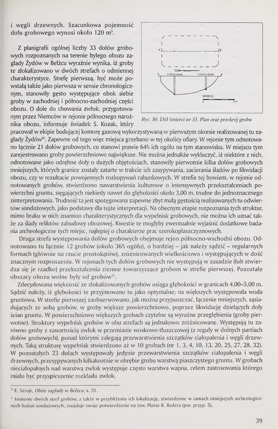
Death pit no. 33 (fig. 50)
A relatively small grave pit registered in the northwestern corner of the present fencing, whose volume extends beyond the fence. The grave was registered on the basis of 2 boreholes (nos. 1732, 1734). In horizontal projection the grave pit reaches dimensions of 9.00 × 5.00 m and depth up to about 3.00 m. Its content consists of mixed structures of cremation remains [continued next page]
Page 38 of the book. Fig. 47. Death pit no. 30, plan and cross-section. Fig. 48. Death pit no. 31, plan and cross-section. Fig. 49. Death pit no. 32, plan and cross-sections.
[Page 39]
and charcoal. Estimated capacity of the grave pit is about 120 m³.
From the planigraphy of the total number of 33 grave pits identified on the area of the former extermination camp for Jews at Bełżec it clearly follows that these graves were localized in two zones of differing characteristics. The first zone, perhaps formed first in chronological order as well, was constituted by the densely-occurring graves alongside one another in the western and northwestern part of the camp. The witness S. Kozak, who worked on the team building the gas chamber used in the first period of the realized extermination of Jews here, informs about a pit for burying corpses prepared by the Germans in the region of the northern corner of the camp20. Probably from this place onward, then, the victims were buried in this vicinity. In this region a total of 21 grave pits were noted, which constitutes nearly 64% of their total at this site. In this place the surface-largest graves were registered. It cannot, however, be excluded that some of them, noted as separate pits of large volumes, originally constituted several smaller grave pits whose boundaries were erased in the course of their filling, the erasure of traces after the liquidation of the camp, or as a result of postwar plundering excavations. In this zone, in the region of the noted graves, cultural strata were found with intensive transformations of the ground surface, reaching sometimes to depths of about 3.00 m, difficult to interpret unambiguously. This difficulty is probably intensified by too low a density of the survey boreholes carried out here, as the basis for this interpretation. At the present stage of recognition of these structures, despite the absence in them of marks characteristic of grave fillings, they cannot also be considered as traces of relicts of camp construction. These questions could perhaps be clarified by additional archaeological investigations of these places, preferably of a wide-area character.
The second zone of grave-pit occurrence covers the northeastern region of the camp. A total of 12 graves were noted here (about 36% of the total), of more, as one must judge, regular forms (chiefly in the projection of rectangles), varied in size and occurring in fairly considerable dispersion. In the regions of these grave pits there essentially do not occur (or they are found rarely) earth transformations accompanying the graves in the first zone. The remaining areas of the camp were free of graves21.
The decided majority of the localized graves reach depths in the range 4.00-5.00 m. It must be supposed that these depths were adopted here as optimal; at greater depths groundwater occurred. In the first zone there was observed, as one may suppose, the joining of smaller adjacent graves into surface-larger graves, by means of liquidation of the earth walls dividing the pits. In surface-larger graves clear depressions are readable (the original graves). The structures of grave fillings in both zones are equally varied. There occur both graves with content of corpses in wax-fat transformation (as a rule in the lower parts of the grave pits), above which lie interlayerings of cremation remains and charcoal. Such a structure of fillings was found in as many as 10 graves (nos. 1, 3, 4, 10, 13, 20, 25, 27, 28, 32). In the remaining 23 pits there occurred only interlayerings of cremation remains and charcoal, covered several times within the grave with a layer of sandy soil. In non-cremation graves, above the layer of corpses, there often occurs a layer of lime, the purpose of whose application was to be the acceleration of the decomposition of the corpses.
20 E. Szrojt, Obóz zagłady w Bełżcu, p. 35.
21 The existence of two grave zones, and also approximately their localization, established within the framework of the present archaeological survey investigations, finds its confirmation on the so-called Plan of R. Reder (cf. footnote 5).
Page 39 of the book. End of the grave catalog (Pit 33) and the synthesis paragraphs distinguishing the two grave zones (NW = 21 pits = 64%; NE = 12 pits = 36%) and the two fill types (10 graves with adipocere bodies + cremation overlay; 23 graves cremation-only). Fig. 50, Death pit no. 33, plan and cross-section.
[Page 40]
The total surface area of the grave pits on the territory of the camp is about 0.52 ha, which constitutes barely 9% of the area of the camp covered by the present fence. The combined capacity of the grave pits is estimated at about 21,000 m³. Such a considerable volume of the graves is in the predominant part constituted by the cremated body remains taking up little space, which illustrates the fact of the liquidation and burial here of hundreds of thousands of people.
Traces of camp construction
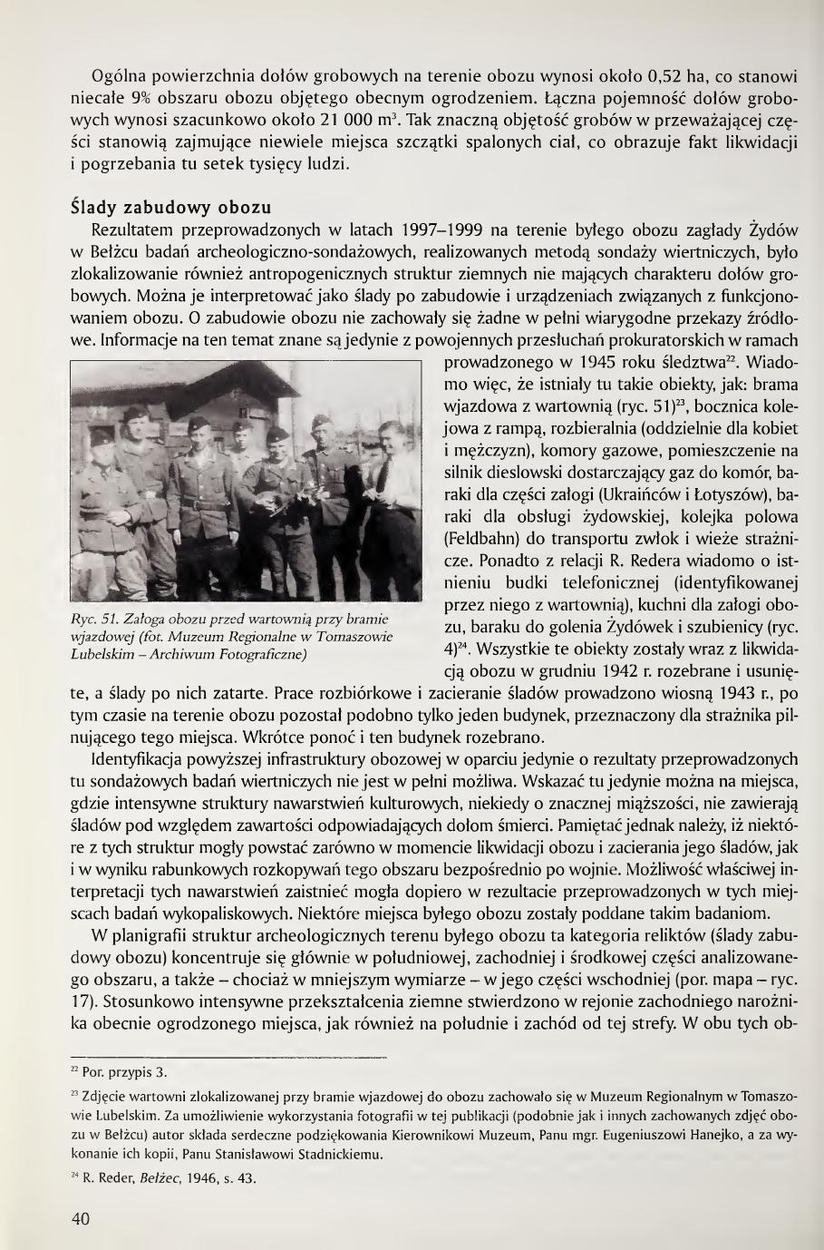
The result of the archaeological-survey investigations carried out in 1997-1999 on the territory of the former extermination camp for Jews at Bełżec, realized by the method of drilling surveys, was also the localization of anthropogenic earth structures not having the character of grave pits. They can be interpreted as traces of construction and installations connected with the functioning of the camp. Of the camp's construction no fully reliable source records have been preserved. Information on this subject is known only from postwar prosecutorial interrogations within the framework of the inquiry conducted in 194522. It is known therefore that there existed here such objects as: an entry gate with a guardhouse (fig. 51)23, a railway siding with a ramp, undressing rooms (separately for women and men), gas chambers, a room for the diesel engine supplying gas to the chambers, barracks for part of the crew (Ukrainians and Latvians), barracks for the Jewish service crew, a field railway (Feldbahn) for transporting corpses, and watchtowers. In addition, from the account of R. Reder, there is known the existence of a telephone booth (identified by him with the guardhouse), a kitchen for the camp crew, a barrack for shaving the heads of Jewish women, and a gallows (fig. 4)24. All of these objects were, with the liquidation of the camp in December 1942, dismantled and removed, and traces of them erased. The dismantling work and the erasure of traces were conducted in the spring of 1943; after this time only one building reportedly remained on the territory of the camp, designated for the guard watching this place. Soon, reportedly, this building too was dismantled.
The identification of the above camp infrastructure based solely on the results of the drilling surveys carried out here is not fully possible. One can here only point to places where intensive structures of cultural strata, sometimes of considerable thickness, do not contain traces corresponding in content to death pits. It must, however, be remembered that some of these structures could have arisen both at the moment of the liquidation of the camp and the erasure of its traces, and as a result of plundering excavations of this area immediately after the war. The possibility of proper interpretation of these strata could arise only as a result of excavation investigations carried out at these places. Some places of the former camp were subjected to such investigations.
In the planigraphy of archaeological structures of the territory of the former camp this category of relicts (traces of camp construction) is concentrated chiefly in the southern, western, and central parts of the analyzed area, and also, though to a lesser extent, in its eastern part (cf. map, fig. 17). Relatively intensive earth transformations were found in the region of the western corner of the currently fenced place, as well as south and west of this zone. In both these areas [continued next page]
22 Cf. footnote 3.
23 A photograph of the guardhouse located by the entry gate to the camp has been preserved in the Regional Museum in Tomaszów Lubelski. For making this photograph available for use in this publication (similarly as other preserved photographs of the camp at Bełżec), the author offers cordial thanks to the Director of the Museum, Mr. M.A. Eugeniusz Hanejko, and for making copies of them, to Mr. Stanisław Stadnicki.
24 R. Reder, Bełżec, 1946, p. 43.
Page 40 of the book. Total grave area ca. 0.52 ha = ~9% of the fenced site; combined capacity ca. 21,000 m³. Opening of "Ślady zabudowy obozu" (Traces of camp construction). Fig. 51, the camp crew before the guardhouse at the entry gate (photo Regional Museum in Tomaszów Lubelski, Photographic Archive).
[Page 41]
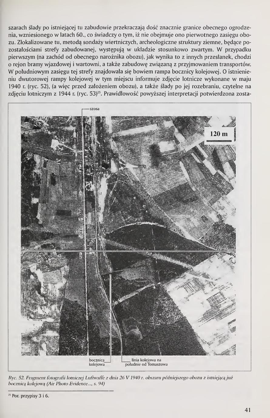
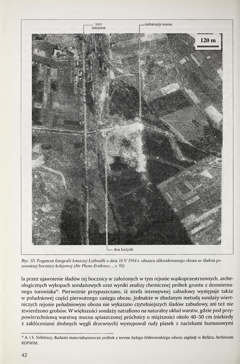
traces of the construction once existing here exceed quite considerably the boundaries of the present fence erected in the 1960s, which testifies that this fence does not encompass the original extent of the camp. The archaeological earth structures localized here by the method of drilling surveys, being the remains of the built-up zone, occur in a relatively compact arrangement. In the first case (west of the present corner of the camp), as follows from other premises, this concerns the region of the entry gate and the guardhouse, as well as the construction connected with receiving transports. In the southern reach of this zone there was the ramp of the railway siding. The existence of a two-track railway ramp at this place is reported by an aerial photograph taken in May 1940 (fig. 52), that is, before the founding of the camp, as well as by traces of its dismantling, readable on the aerial photograph of 1944 (fig. 53)25. The correctness of the above interpretation has been confirmed [continued next page]
25 Cf. footnotes 3 and 6.
Page 41 of the book. Fig. 52. Fragment of a Luftwaffe aerial photograph of 26 May 1940 showing the area of the later camp, with the railway siding already in existence (Air Photo Evidence..., p. 94).
[Page 42]
by the disclosure of traces of this siding in the narrow-area archaeological survey trenches established in this region, and by the results of chemical analysis of soil samples from the presumed track-bed26. It was originally supposed that a zone of intensive construction also occurs in the southern part of the original extent of the camp. However, in the southern region of the camp investigated by the method of drilling surveys, no clearer traces of construction were demonstrated, nor were graves found. In the majority of surveys a natural arrangement of layers was encountered, where beneath a near-surface layer of strongly sandy humus of about 40-50 cm thickness (sometimes with disturbances of small charcoal pieces) there occurred rusty sand with humus seeps [continued next page]
26 A. and S. Skibiński, Badania materiałoznawcze próbek z terenu byłego hitlerowskiego obozu zagłady w Bełżcu, Archive ROPWiM.
Page 42 of the book. Fig. 53. Fragment of a Luftwaffe aerial photograph of 16 May 1944 showing the area of the liquidated camp with the trace of the removed railway siding (Air Photo Evidence..., p. 95).
[Page 43]
and humus inclusions, reaching on average to a depth of about 1.00 m. Below was found the lying of a whitish-yellow sand layer (subsoil), which from a depth of about 1.50 m passed into a strongly compacted sand of whitish color. Quite considerable near-surface disturbances were found, however, in the boreholes carried out in the strip of the course of the camp railway siding, which were characterized by the occurrence to a depth of 1.50-1.60 m of intensive small particles of charcoal as well as mixed earth structures, being the result of leveling the area for the constructed track-bed. In some boreholes these disturbances reached fairly deep, to about 2.40 m. The character of these relicts can be clarified only by the excavation method.
Considerable diversity of strata was noted in the surveys localized in the region situated west of the present fence (hectare XIV), where in reconnaissance research boreholes earth structures corresponding to more closely undefined construction were encountered. In some boreholes, however, beyond small particles of charcoal, traces of decayed wood, glass, and undefined metal objects, fragments of bricks and fabrics, the occurrence of small particles of burnt human bones was found. In these last cases the western reach of the extensive cremation grave noted here as grave no. 14, which originally could have constituted several smaller adjacent graves, was probably encountered. The functions of the objects revealed in the remaining boreholes of this hectare are at the present stage of investigations difficult to interpret. Perhaps certain clarifications could be obtained by densifying the drilling surveys or by carrying out wide-area archaeological research trenches.
In the central part of the camp over 30 places were encountered attesting to the existence of traces of more closely undefined construction. It was most compact in the northern region of this zone, around the present central monument. In the remaining zone of this part traces of construction occurred in dispersion. The archaeological structures registered in the survey boreholes in many cases inform of the existence in the ground of foundation remains of this construction, not fully removed during the liquidation of the camp and the erasure of its traces in 1943. Their identification can occur only after carrying out wide-area archaeological work here, not included to a wider extent in the program of the discussed investigations, which had mainly a survey character. Only four places of the noting of such foundation structures of this part of the camp (the central) were subjected to more detailed verification, by investigating these places by archaeological narrow-area surveys. In the central part of the camp two places of disturbances of near-surface strata noted by drilling surveys were also identified by the excavation method, as well as a region of a concentration of lime already readable on the surface of the ground.
Traces of more closely undefined construction were also noted in the survey boreholes in the eastern part of the camp within the reach of the 1960s fence, and farther east beyond the fence. The latter were established in reconnaissance boreholes near the eastern corner of the fence; perhaps more of them occur on the area not yet subjected to investigations, beyond the present fence.
Relics of camp infrastructure (narrow-area survey trenches)
Independently of the archaeological reconnaissance of the area of the camp carried out by the method of drilling surveys, in several places of anthropogenic structures of non-grave character thus established, an examination of the cultural strata was undertaken for verification of the hypotheses set for these places. In one case this concerned grasping the course of the railway siding within the camp; in several others it was decided to investigate in more detail the foundation relicts of construction noted in boreholes in the central and western part of the investigated area. In addition, a research trench was established at the place of the presumed outer fencing, northeast of the camp.
Railway ramp (figs. 52-57)
From the present configuration of the area situated south of the existing fence (hectare XXVIII), which is connected, as one may suppose, to the state from the period of the camp's functioning, it follows that the railway siding, readable on the already mentioned aerial photographs of the 1940s, could reach [continued next page]
Page 43 of the book. Text-only page covering the camp railway-siding stratigraphy, the western (hectare XIV) zone of unidentified construction, the central camp zone (over 30 places of foundation remains around the central monument), and the eastern beyond-fence traces. New section opening: "Relics of camp infrastructure (narrow-area survey trenches)" with the ramp subsection beginning.
[Page 44]
Page 44 of the book (figure-dominant). Fig. 54. Survey trench no. 3/97, profile of the trench with traces of the railway-ramp track-beds. Fig. 55. Reconstruction of the localization of the railway-ramp track-beds. Legend: dashed boxes = presumed traces of wooden platforms (remains of posts and joists); double dashed lines = presumed course of the track-beds.
[Page 45]
as far as the central parts of this hectare. On the presumed line of the course of this siding 4 survey trenches were established to verify this hypothesis. Trench no. 1/97 of dimensions 8.00 × 1.00 m was localized on hectare XXVIII, ar 42; trench no. 2/97 of dimensions 14.00 × 1.00 m on hectare XXII, ars 6 and 16; trench 3/97 of dimensions 10.00 × 1.00 m on hectare XXVII, ars 17 and 18; and trench 4/97 of dimensions 8.50 × 1.00 m, with a profile extended for interpretive purposes by 3.00 m entering onto the presumed ramp, on hectare XXVII, ars 30 and 40.
Analysis of the longitudinal profiles in the above survey trenches, except for trench 1/97, indicates beyond doubt the grasping here of basins (depressions) of the railway siding's track-beds, with a fill of intensively dark earth, formed as a result of its greasing and disturbance with refuse from the locomotive fireboxes. Such a structure of the earth was confirmed by chemical analyses of samples taken from this track-bed27. The mutual arrangement of these basins in trenches 2/97, 3/97, and 4/97 forms clear sequences of two track-beds slightly diverging from each other in the western direction (fig. 56). The width of the basins of these track-beds was about 2.00 m. The traces of posts found between the track-beds (trenches 3/97 and 4/97) may be relicts of the bases of wooden platforms. The embankment of anthropogenic character occurring along the southern track-bed, in its eastern part (registered in the southern, widened part of trench 4/97), may constitute a remainder of the railway ramp existing here. Even at present this embankment is elevated about 1.10 m above the top of the basin of the former track-bed. It must be added that in the course of the exploration of this place a railway switch lamp in good state of preservation was found (fig. 57). The chronology of the use of such lamps in the Polish railway system reaches back to the interwar period.
Building A (figs. 58-61)
Traces of this building were originally encountered in two basic boreholes (nos. 468, 473), in the central part of hectare XV, on ars 36, 37, 46, and 47. Given the selection of this object for more detailed investigation by the method of narrow-area surveys, for the more precise determination of the extent of the building and the most appropriate placement of archaeological trenches, several further boreholes were carried out here detailing its localization.
27 A. and S. Skibiński, op. cit.
Page 45 of the book. Text covering the four ramp survey trenches (1/97, 2/97, 3/97, 4/97), confirmation of two parallel track-beds ~2 m wide diverging slightly westward, the railway switch lamp find (interwar Polish railway equipment), and the opening of the Building A subsection.
[Page 46]
Mixed earth structures, but already of lesser thickness, being the result of leveling the place after the dismantled building, also occurred in the adjacent boreholes (nos. 466, 475, 477). The earth relicts of this building in the boreholes were marked by a structure of strata with cultural content attesting to intensive use. In the near-surface strata the occurrence of charcoal was found; lower down were noted decayed and partly burnt wood, fragments of window and bottle glass, iron nails, and pieces of iron wire. Sporadically, in the bit-pen from some boreholes, fragments of human bones were also extracted (borehole no. 548).
For investigating the relicts of this building two research trenches were established of dimensions 6.00 × 2.50 m, distant from each other by 3.00 m. The first of them (no. 5/98) was localized on the boundary of ars 46 and 47; the second (no. 6/98) occurred on four ars: 36, 37, 46, and 47. In both these trenches were uncovered opposing fragments [continued next page]
Page 46 of the book. Fig. 57. Railway switch lamp found in the region of the camp railway ramp (photo R. Kola). Fig. 58. Building A, profiles of the relicts of the building.
[Page 47]
of walls of a wooden building recessed into the ground, erected on the plan of an elongated rectangle, of dimensions about 4.65 × 1.65 m. The constructions of its longer walls have not survived. The lower, sub-surface fragments of the shorter walls were built of thick boards 4 cm thick, installed in horizontal arrangement, supported from the inside by three vertical posts, in cross-section quadrilateral, of dimensions 8 × 12 cm (corner of the building, see fig. 61). In the better-preserved southern wall of the building, 6 courses of boards still remained. The lower edge of the lowest-lying of them rested at a depth of 2.70 m.
From the strata within this building, numerous objects of personal use were extracted, such as: a double-sided comb, fragments of plastic combs (fig. 104), an iron and aluminum box lid, a fragment of a bronze plate with the inscription "CREM," Polish coins, a brass stamp/seal (fig. 102), a round eyeglass lens, a glass ampoule (fig. 108), a ceramic bead [continued next page]
Page 47 of the book. Description of Building A, wooden recessed structure 4.65 × 1.65 m, walls preserved to 2.70 m depth, six courses of 4 cm boards in the better-preserved southern wall. Fig. 59. Building A, reconstruction of the plan of the building.
[Page 48]
in the shape of a wild strawberry, cufflinks, a metal watch case, a glass stopper from a carafe, a thermometer scale, a plastic hair clip, a silvered teaspoon and the handle of a spoon, a porcelain bottle stopper, a metal zipper, and a rifle cartridge case. Also noted here were destruction fragments of shoes, suitcases, glass and ceramic vessels, etc. In mixing there also occurred, in secondary deposit, several dozen fragments of human bones, in part burnt.
Page 48 of the book. Fig. 60. Building A, outline of the relicts of the building at a depth of 70-80 cm in trench 5/98 (photo A. Kola). Fig. 61. Building A, relict of the wooden wall in trench 5/98 (photo A. Kola). Body text continues the personal-objects inventory: ceramic strawberry-shaped bead, cufflinks, metal watch case, glass carafe stopper, thermometer scale, plastic hair clip, silvered teaspoon, porcelain bottle stopper, metal zipper, rifle cartridge case, plus destruction fragments of shoes, suitcases, glass and ceramic vessels, and dozens of partly burnt human bone fragments in secondary deposit.
[Page 49]
It is difficult to attempt an interpretation of the function of this building. The considerable depth of the lying of this construction (to 2.70 m), with the relatively small size in horizontal projection of about 7.80 m², would allow one to consider it a dugout structure of unclear designation. In such an interpretation it would not have an above-ground floor. One can, however, see in this wooden underground room an object of the type of a cellar lying beneath an above-ground building, perhaps of considerably larger area than in the earth part. Its presence was indicated by cultural strata noted in this place in several drilling surveys.
Building B (figs. 62-65)
Relicts of this building were initially registered in two basic boreholes (nos. 1061 and 1062), in which mixed cultural strata reaching to a depth of about 2.90 m were found, containing brick rubble down to a depth of 1.50 m, and at a depth of about 2.30 m, charcoal. After the decision to investigate this object by the method of narrow-area surveys, further boreholes were carried out, densifying their grid in this place every 1.00 m, or every 2.00 m (boreholes nos. 1064, 1065, 1067, 1068, 1070, 1073-1075, 1079, 1082-1084). In these boreholes also cultural strata of thickness from 1.10 to 1.90 m of similar content were found; in the majority of them brick rubble, charcoal, and decayed wood occurred.
For investigating these relicts, originally two research trenches were laid out in hectare XV: the first (no. 7/98), of dimensions 5.00 × 3.00 m, localized at the intersection of ars 53, 54, 63, and 64; the second (no. 8/98), of dimensions 6.00 × 4.00 m, on the boundary of ars 63 and 64. They were distant from each other by 2.00 m. In these trenches the relicts were encountered of a building recessed into the ground of dimensions 7.00 × 2.75 m, erected entirely of brick, without a separately-distinguished foundation course. The wall had a thickness of 25 cm (the length of a brick). The two lowest courses of bricks of the walls of this building were recessed below the inner concrete floor [continued next page]
Page 49 of the book. Building A interpretive paragraph (dugout vs. cellar of larger above-ground structure, function indeterminate from sondage alone). Opening of Building B subsection. Fig. 62. Building B, profiles of the relicts of the building. Legend: humus / brown-grey sandy earth; mixed grey-white sandy earth; grey-brown earth; mixed brown-grey earth; rusty sand; concrete; mixed grey-yellow earth; original humus; brick; stones; subsoil, undisturbed yellow-green clay; cross-section of wall.
[Page 50]
about 4 cm thick, laid on the sandy subsoil. In trench no. 8/98 fragments of three walls of this building were preserved to a height of 9 courses of bricks. The eastern wall of the building in this trench, under the pressure of earth from outside, had collapsed inward. The relicts of the remaining two walls were preserved in the original arrangement. The inner facing of the walls was smoothed with cement-lime mortar (fig. 63). In trench no. 7/98 only a fragment of the concrete floor of the building was preserved with a scatter of brick rubble. In both trenches this floor occurred at a depth of about 2.00 m from the present surface of the area.
The above identification of the cellar structures of this building in its outer parts within the framework of trenches 7/98 and 8/98 was supplemented by investigations of its central part with the supplementary trench 8a/98, of dimensions 2.00 × 5.00 m, obtaining in this way the totality of its plan. In the fill of this construction there occurred a large concentration of soot-blackened boulders, a sack of fossilized cement (on its surface are imprinted traces of a jute sack with a sewn-on patch). Apart from this, numerous objects of everyday use were found here, such as: two small bottles with the inscription J.A. Baczewski Lwów 1792, an iron nail for fastening railway rails, fragments of medicine bottles, fragments of plastic combs, mess-kit pots, a bronze brooch, a silver lid of a cigarette case, whole and fragmentary spoons and teaspoons (fig. 113), (including one teaspoon with an engraved swastika, fig. 114), Polish coins, a gold 10-rouble coin, glass medicine phials, a glass ornament in the shape of a ball, a white plastic bead, dental prostheses, plastic plates with an applied Star of David (fig. 94), eyeglass lenses, cartridge cases from a Mosin rifle of Soviet manufacture, two metal spoons, a fragment of a metal cigarette case, an aluminum vial from insulin, and other small objects or their destruction fragments.
Similarly to the construction presented above, designated here as Building A, this building also, recessed into the ground to a depth of about 2.00 m, with a total external area of 19.25 m² and an internal area of about 14.60 m², could have constituted the cellar part of an above-ground building of larger area, or also a dugout structure. In both these hypothetical inferences, the function of this construction, on the basis only of survey investigations, is not possible to determine.
Page 50 of the book. Building B finds inventory: J.A. Baczewski Lwów 1792 bottles, swastika-engraved teaspoon, gold 10-rouble coin, dental prostheses, plastic plates with Star of David, Soviet Mosin cartridges, insulin vial, etc. Fig. 63. Building B, fragment of the relicts of the building in trench 8/98 (photo R. Kaźmierczak).
[Page 51]
Page 51 of the book (full-page figure plate, no body text). Fig. 64. Building B, outline of the relicts of the building. Fig. 65. Building B, trench 8/98, north profile of the trench (photo A. Kola).
[Page 52]
Building C (figs. 66, 67)
In contrast to the previous ones, this object, conventionally called Building C, was already legibly outlined on the surface of the ground in hectare XIV, ar 90 and hectare XV, ar 81, in the form of a concrete crown of walls of a more closely undefined construction, erected on a horizontal projection close to a square. On the territory of the former camp it was the only, as one may judge, object whose outer walls in the earth part have been preserved entirely. Given the manifestation of this construction on the ground surface and its small size in horizontal projection, by the local population it was called (also at present) the well. In its immediate vicinity one of the basic boreholes was carried out here (no. 730), in which to about 80 cm brick rubble occurred, and at a depth of about 1.00 m, sandy subsoil. In other basic boreholes in this region, already at a depth of about 40-50 cm, parent ground in the form of sand occurred. Investigations of this object consisted only in archaeological exploration of its interior. They were conducted to a depth of about 1.40-1.50 m, where an undamaged concrete floor was encountered. This object in horizontal projection reached external dimensions of about 3.00 × 2.70 m, with interior dimensions of about 2.50 × 2.20 m. Its interior surface area thus amounted to about 5.50 m². In the four corners of the interior, in the concrete floor, openings of various shapes were located, with traces of decayed wood. On the inner facing of the concrete walls 20-25 cm thick, traces of horizontal formwork boards were clearly marked (fig. 67). The above observations thus allow conclusions about the technique of construction of this object. It was erected by filling with wet concrete, mixed with furnace slag, the formwork-supported walls of the excavation, leaning on vertical posts placed in the corners. Then, without removing the posts, in this room a concrete floor was laid. These posts, as one must judge, remained in these places for a considerable period of time, leaving traces of decayed wood.
Page 52 of the book. Opening of "Budynek C" subsection. Fig. 66. Building C, plan and cross-section of the relicts of the building, with leveling-point heights labeled in m a.s.l.
[Page 53]
One can therefore suppose that the formwork boards held by these posts were also not removed after the hardening of the concrete in the walls, constituting a certain thermal insulation of the walls during the period of the construction's functioning.
In the fill of this room during exploration the following were found: a sapper shovel, plastic combs, glass bottles, a key, spoons and teaspoons, cast-iron stove legs, a toothbrush, a fragment of a mirror with a child's photograph (fig. 105), a fragment of a plastic plate with a Star of David applied to it, and other destruction fragments of objects, mostly personal.
Also in this case the designation of this object recessed into the ground is not known. In terms of surface area it was smaller than the object designated as Building A, however with a shallower foundation. In the interpretation of its function, similarly as in the previous buildings, one can therefore see in it an independent small dugout of warehouse character, or this construction can also be considered as a recessed-into-the-ground room of a fragmentarily basemented above-ground wooden building, completely dismantled, without clearer traces of it in the cultural strata of this place.
Building D (figs. 68-73)
In the light of the previous recognition of archaeological structures of the territory of the former extermination camp for Jews at Bełżec, the relicts of this building indicate that among the camp construction it belonged to the largest, of relatively solid construction. Foundation parts not removed during the liquidation of the camp have been preserved from it; the above-ground parts of the building were then dismantled completely. Given the absence in this region, in cultural strata, of destruction fragments from the dismantling of masonry walls (rubble, building mortar), it must be supposed that the above-ground construction of this building was erected of wood, and was therefore relatively easy to dismantle. Traces of this building were encountered in 15 exploration units (trenches), which were laid out as successive parts of its relicts were uncovered, expanding the scope of archaeological penetration. Almost all the trenches were located in the southern region of hectare XIX; only two, realized in 1999, were on hectare XX (trench 11j/99 entirely and 11h/99 [continued next page]
Page 53 of the book. Fig. 67. Building C, relicts of the building (photo R. Kaźmierczak). Continuation of Building C interpretation and opening of Building D subsection.
[Page 54]
fragmentarily). The first four trenches covered the surfaces of ar quarters (trench 11/98 on ars 87 and 88, 11a/98 on ar 87, 11b/98 on ars 87 and 88, and 11c/98 on ar 87). The remaining trenches were laid out successively at the edges of the previous ones, to grasp the extent of the uncovered relicts of the building, determining estimated their localization and dimensions: trench 11d/98 of surface area 33.75 m² on ars 76, 77, and 78; 11e/98 of surface area 31.5 m² on ars 86, 87 and 11f/98 of surface area 10 m² on ar 97, as well as trenches realized in 1999, mainly in hectare XIX on ars 95, 96, and 97, trench 11g/99 of surface area 12.25 m²; 11h/99,9.5 m² (partly on ar 6 of hectare XX), 11i/99,14.25 m², 11j/99,12 m² (ars 6 and 7 of hectare XX); 11k/99,3.75 m²; 11l/99,8.75 m²; 11ł/99,12.25 m² and 11m/99 of surface area 6.00 m². Such a wide scope of exploration permitted the full uncovering of the relicts of this construction.
In the light of this recognition it appears as a six-room building. The outer walls of the building rested on stone foundation courses 100-140 cm wide. The distance between the outer faces of these courses across the width of the building is about 13.20 m, which indicates that the width of the building in its above-ground part was about 12 m. The length of the building was about 26.00 m.
In this building there were six surface-identical rooms, of dimensions about 11.60 × 3.80 m, separated from each other by partition walls. Only the southern room (the sixth) was additionally divided into two smaller rooms. The preserved foundation [continued next page]
Page 54 of the book. Fig. 68. Building D, situational plan of the trenches. The figure shows the layout of the 15 research trenches (11/98 through 11m/99) within hectares XIX and XX that uncovered the foundations of the six-room building.
[Page 55]
courses of the inner walls of width about 50-70 cm divided the building in transverse arrangement. They consisted of a concrete underlay, stones, and, fragmentarily, brick. From the stratigraphy of foundation courses captured here it follows that the foundations of the inner walls were added on to the already existing outer courses. The interiors of these rooms were originally covered with concrete flooring on a base of brick rubble. Only in one case the interior of a room (the second from the north) was lined with flat limestone slabs with a cement smoothing, forming a fairly regular floor. Large fragments of this floor still remain along the outer northwestern wall, and to a lesser extent in the eastern corner of the room. In this room there was a brick-built recess (at the stage of investigations designated as object D1). In horizontal projection it had inner dimensions of 6.00 × 1.00 m. The walls of this recess were erected of 11 courses of bricks, plastered on the inside. The combined thickness of the walls with smoothing of plaster was about 30 cm. The bottom of this recess, which undoubtedly fulfilled (perhaps originally) the function of a channel for repairing [continued next page]
Page 55 of the book. Fig. 70. Building D, drawing of the inner wall of the auto-workshop inspection channel (with profiles). Fig. 71. Building D, relicts of the building with the preserved auto-workshop inspection channel (photo R. Kaźmierczak).
[Page 56]
cars, was constituted by a concrete floor. On it, in longitudinal arrangement, were boards, probably playing the role of insulation from the underlay for persons working in the channel. At a distance of 1.20 m from both end walls of the channel (the shorter ones), in the longer walls there were placed in pairs, at a height of 0.80 m from the floor level in the channel, four niches of dimensions: length 0.55 m, height 0.24 m, and depth 0.14 m. They probably served the function of niches for tools and lighting for the persons working in the channel. With respect to the floor level of the room, the floor of the channel was recessed by 1.22 m. In the western edge part of the channel, at the floor level of the room, fragments of a setback served for placing transverse boards for covering the channel. One can suppose that this room served the function of an auto-workshop. To the first room (situated to the north) led legibly outlined doors in the top of the foundation of the partition wall, of width about 1.50 m. Also in the partition wall between the second and third rooms, in its central part, there was a doorway of width about 2.00 m.
Analyzing the stratigraphy of the strata of the area situated outside this building from the eastern side, one can see two utilization levels of this area clearly outlined in the profiles of the trenches. They are marked by two layers of intensive dark humus in horizontal arrangement. The deeper layer, the top of which now lies at a depth of about 80 cm, is the first utilization level of this place. This layer was also found within the building, e.g. beneath the foundation of the partition wall. This level was covered with a layer of crushed limestones of about 40 cm thickness, on which the second utilization level was formed in the form of a 10-15 cm thin layer of dark earth. Its top lies about 25-40 cm beneath the present surface of the ground. The crushed limestone used to raise the area around the building corresponds in its character to the stone material used to lay the floor inside the building. In this way the region of these rooms was hardened. In the light of stratigraphic relations this took place, however, within the framework of the second phase of the management of this place. Chronologically this could have been concurrent with the erection at this place of the building (D) with six rooms separated within it.
In the strata of the interior of the building numerous objects were found, often already in a state of destruction, belonging probably in the majority to the victims brought to the camp, or to the work commandos consisting of Jews. These are, among others: fragments of combs, small bottles after medicines [continued next page]
Page 56 of the book. Fig. 72. Building D, interior of the preserved auto-workshop inspection channel (photo R. Kaźmierczak).
[Page 57]
and perfumes, a lead seal, rifle cartridge cases, fragments and complete specimens of spoons, forks, and table knives, various metal boxes, mugs, a metal pot, elements of railway-rail fastenings, and others. Worthy of particular attention was found within the stone floor, in the western part of the central room of the building, in clear concentration (trench 11e/98), a collection of 304 fragments of concrete disks of diameter about 6 cm and thickness 1 cm, on which the impression of 5-digit numbers was found (inv. nos. of finds 233/98). In the preserved upper fragments of these disks were small openings, probably serving for hanging. The designation of the disks is not known (figs. 115-117).
Building E (fig. 74)
The relicts of this building occurred in hectare XXI, ars 40 and 50, and in hectare XXII, ars 31 and 41. In the survey boreholes this place was characterized by the intensity of cultural strata of thickness up to 190 cm, the content of which indicated the existence here of a non-grave object. At the same time, in the boreholes no relicts of brick rubble were encountered, which raised interest as to the function of this cultural object. Excavation investigations of this place were originally undertaken with a trench of dimensions 4.00 × 3.00 m (trench 12/98), then expanded by an area of 4.00 × 1.50 m (trench 12a/98). Thus altogether an area of 18.00 m² was investigated by excavation here, which covered, as it turned out, a significant part of the established relicts of this building. It was a completely wooden building, dug into the sandy ground to a depth of about 1.60 m (and so perhaps basemented). It was completely dismantled, and the wooden material from its construction removed. As a consequence, at the place of the building a depression formed, which was finally leveled, probably still during the liquidation of the camp. The dimensions of the building were quite clearly outlined in the lower parts of the strata. They amounted to approximately 2.40 × 3.00 m. In the cultural content of the fill of its relicts, a significant number of various objects was encountered. Among them, objects and their destruction fragments connected with medical activities predominate. Here must be mentioned: ampoules from injections, including still full (unused) [continued next page]
Page 57 of the book. Fig. 73. Building D, relicts of the building (photo R. Kaźmierczak). Discussion of the 304 numbered concrete disks (~6 cm diameter, 1 cm thick, 5-digit stamped numbers, with hanging holes, designation unknown). Opening of Building E subsection.
[Page 58]
small bottles of medicines, plastic medicine packaging, a syringe needle, aspirin packaging, a fragment of a thermometer, glass medical cups, scissors. Worthy of attention is a phial with the inscription in Polish,strychnina [strychnine]. Of other objects were found here: several armbands with a Star of David (fig. 94), a medallion with a Star of David (fig. 101), fragments of metal cutlery, lids from metal cigarette cases, fragments of plastic combs and brushes, and shaving razors, several Polish coins. The better-preserved objects were noted in the Inventory of finds..., with their designation for conservation (182 inventory positions,109/98 to 291/98). A significant number, however, of the objects found here, particularly iron ones, was characterized by very poor state of preservation. Information on these finds was given only in the Diary of the archaeological expedition..., and these destruction fragments were left at the place (figs. 89-93). Attention should also be drawn to the fact that in the fill of the relicts of this building a fairly significant number of animal bones occurred. The majority of them, however, were extracted from near-surface strata (to a depth of 70 cm) and may have ended up at this place after the dismantling of the object.
The function of this small wooden building is not fully clear. Its relatively small dimensions in the earth part, with the absence at this place of cultural strata of wider extent, argue for the fact that in the above-ground story the projection of the building did not differ from its dimensions established archaeologically. In the fill of the relicts of the building attention is drawn by the occurrence of numerous objects connected with medical activities. Such cultural content distinguishes this object among other archaeologically investigated relicts of buildings on the territory of the camp, where in principle objects of such character were not found. It is not excluded that in this building was located a medical post serving the camp services.
Building F (figs. 75-76)
The relicts of this small building (room) were encountered in hectare XXI, ar 3. It was originally located in the central part of the camp, however currently just behind the main gate of the fence. The relicts of the building were investigated by encompassing them with a research trench of dimensions 2.10 × 2.30 m (trench 20/99). It was a small masonry room, of which only foundation parts and, fragmentarily, one, the lowest course of bricks of the outer walls, have been preserved. The preserved top of these relicts occurred directly beneath the contemporary turf (fig. 76). The foundation course of the building was constituted by concrete, forming a base on a projection close to a square of outer dimensions about 1.40 × 1.50 m. The thickness of this course was about 30-40 cm, with its depth about 30-35 cm. On this foundation, before the concrete had hardened, the walls of the room began to be erected of bricks of wall thickness 1/2 brick (12 cm). On one of the bricks lodged in the preserved layer of the wall the date of its production "8-40" (i.e. August 1940) was noted. In horizontal projection the outer dimensions of this room were 1.30 × 1.50 m. Undoubtedly we are dealing here with a relict of a guardhouse located in the central part of the camp, in the zone separating the region of the death pits from the camp construction of the region for receiving transports and preparatory activities before directing victims to the gas chamber.
Page 58 of the book. Fig. 74. Building E, traces of the relicts of the building (photo R. Kaźmierczak). Building E finds list (medical objects: ampoules, syringe needle, aspirin packaging, thermometer fragment, scissors, glass medical cups, strychnine phial, Star of David armbands and medallion). Opening of Building F subsection.
[Page 59]
Page 59 of the book (full-page figure plate). Fig. 75. Building F, horizontal projection and cross-section of the relicts of the building. Fig. 76. Building F, relicts of the foundations of the building (photo R. Kaźmierczak).
[Page 60]
Building G (fig. 78)
In the northern part of the camp, in the northwestern region of hectare XVI, drilling surveys revealed the occurrence of more closely undefined archaeological structures of non-grave character. At this place three adjacent survey trenches were laid out of various shapes and sizes (trenches 15/99, 15a/99, and 15b/99). They revealed the occurrence here of a negative imprint of a more closely undefined building, erected undoubtedly entirely of wood, partially recessed into the ground, which was completely dismantled. In horizontal projection the relicts of the trench determining the plan of the building outlined themselves as a regular rectangle of dimensions about 3.50 × 15.00 m, the floor of which lay in horizontal arrangement to a depth of about 80 cm. The fill of this trench consisted of dark, strongly compacted humus, legibly outlined against the background of the sandy parent ground. The cultural content of the fill consisted of numerous fragments of tar paper and iron nails, undoubtedly coming from the above-ground construction of the building. In addition, in the strata of these relicts a few fragments of dental prostheses, women's combs, and two Polish coins of grosz denominations were found. Perhaps this wooden building fulfilled the function of a gas chamber in the second phase of the camp's functioning, in autumn and winter 1942. Such an interpretation could be confirmed by its situation in the planigraphy of the camp. From the northeastern and eastern sides of this building archaeological drilling surveys revealed only the occurrence of mass death pits. The location of the gas chamber near the place of burying corpses in the second phase of the camp is confirmed by the accounts of certain witnesses28.
28 R. Reder, Bełżec, p. 44. This witness reports that in the second phase of the camp the gas chamber was located in the immediate region of the graves. According to him, however, this chamber was made of concrete. The survey investigations carried out in this region revealed no traces of masonry or concrete construction, which undermines the credibility of the account in this respect.
Page 60 of the book. Fig. 77. Building F, brick with the firing date "8-40" (photo R. Kaźmierczak). Opening of Building G subsection, possibly the second-phase wooden gas chamber based on its proximity to the death pits in the NE camp section.
[Page 61]
Building H (fig. 79)
Traces of a more closely undefined construction were encountered in hectare XV, on ars 91 and 92, near the present gate leading onto the area of the camp. During the camp's functioning this construction lay in its central part. Archaeological drilling surveys revealed at this place clear disturbances of earth structures in the form of dark, compacted humus, however without traces of building material. To clarify the causes of these disturbances an archaeological trench was laid out in the shape of two ditches intersecting at a right angle, of width 1.50 m and length 8.00 m (trench 19/99). In the northeastern part of this trench the zone of archaeological observation was expanded by an additional excavation of dimensions 3.00 × 1.00 m (trench 19a/99).
Exploration of the cultural strata occurring here revealed the existence at this place of relicts of a more closely undefined construction. Given the absence in these strata of traces of masonry construction, it must be accepted that it was erected of wood and could have had the character of a barrack. Quite troublesome, however, is the determination of its dimensions. Analysis of the profiles of both archaeological trenches in which the relicts of this construction were investigated showed that this building was recessed in the sandy ground to a depth of about 1.60 m. Its floor at this depth had a horizontal arrangement, marking the bottom of the recessed-into-the-earth room of the building, and the lower parts of the walls were vertical. Assuming that these walls mark the extent of the building, one can judge its dimensions, which would be about 4.80 × 4.80 m. In this case the building must have been considerably recessed into the ground. However, the upper parts of the trench have a considerably larger extent, and perhaps these mark the original above-ground projection of the building, of dimensions reaching 8.00 × 7.00 m. If such an interpretation is correct, the previously given dimensions would concern only the partly basemented part of the building. The state of preservation of the relicts of this construction in the form of only an archaeologically confirmed excavation after it does not allow here for unambiguous interpretation.
Page 61 of the book. Fig. 78. Building G, relicts of the building and profile at a depth of 60-70 cm (photo R. Kaźmierczak). Opening of Building H subsection.
[Page 62]
Equally troublesome is the interpretation as to the function of this object. Attention is drawn here to the lying in its relicts of a fairly significant number of various objects, mostly in very poor state of preservation, but of which a selected part of over two hundred was preserved for the purposes of conservation and future exhibition. Apart from objects that certainly belonged to the victims (combs, dental prostheses, fragments of boxes, teaspoons, toothbrushes, plastic plaques with a Star of David, small boxes for tablets (fig. 103), and small bottles of medicines (figs. 108, 109), buttons, keys, etc.), attention is drawn by tools, such as: a file, a carpenter's clamp, scissors, pliers, that is, tools that could have been used in camp activities. Perhaps this barrack thus served for receiving and selecting items obtained from the victims.
Lime deposit (fig. 80)
At a distance of about 15-20 m to the SE from Building F, in hectare XVI, ars 43 and 44 (trenches 13/99, 13A/99, and 13B/99), at a depth of about 20-30 cm from the surface of the earth a layer of lime was encountered (originally probably burnt). This lime now occurs in the form of a layer of thickness 10-20 cm, in the form of an irregular patch, of dimensions in horizontal projection about 5.00 × 2.50 m, lying on the original humus. Beside this concentration, on the S and SW side, smaller patches of lime lay of horizontal projections 2.00 × 0.50 m and 2.60 × 1.40 m. In this last concentration, a fossilized cement-lime block of more closely undefined function was additionally found. The lying of these concentrations of lime in the region of the localized death pits permits an unambiguous interpretation of its purpose, as a means for accelerating the decomposition of bodies, and at the same time an immediate means of disinfection. Witness accounts confirm the use of lime for such purposes in Hitlerite extermination camps.
Presumed outer fence
Topographic analysis of the camp region in correlation with the analysis of aerial photographs of this place from the years 1940 and 1944 allows the supposition of the existence at a certain distance to the northeast [continued next page]
Page 62 of the book. Continuation of Building H finds inventory (over 200 conservation items: combs, dental prostheses, Star of David plastic plaques, tablet boxes, medicine bottles, buttons, keys; tools, file, carpenter's clamp, scissors, pliers, possibly an items-sorting barrack). New subsections: "Składowisko wapna" (Lime deposit) and "Domniemane ogrodzenie zewnętrzne" (Presumed outer fence).
[Page 63]
(about 50 m) and to the east of the camp (about 100-120 m) of an additional outer fence. Even at present in the wooded area clearings are legible here; to the northeast of the camp this clearing is covered with concrete slabs in the type of a hardened track. Verification of this hypothesis was carried out by laying out at the presumed place of occurrence of the fence, in hectare X, ars 58 and 68, a research survey trench of dimensions 5.00 × 4.00 m (trench 10/98). At a depth of about 40-60 cm a trace of a road existing here was outlined in the trench, on whose boundary from the camp side a clear trace appeared of a wooden post of diameter about 20 cm, perhaps from the construction of the fence. Only further archaeological recognition of this place can, however, confirm or exclude the hypothesis put forward, the more so as this trench did not provide any objects of dating value.
Survey trenches in the western part of the camp
In hectare XIV on ars 66 and 67, north of Building D, three archaeological survey trenches were laid out (14/99, 14a/99, and 16/99), the aim of which was to be the verification of the localization of the presumed narrow-gauge railway, by which in the first phase of the camp's functioning corpses were said to be transported from the gas chamber to the death pits29. This was connected with the attempt to interpret the function of Building D as a gas chamber. However, traces of the railway were not encountered in these trenches. In trenches 14/99 and 14a/99 (fig. 81) was encountered, instead, a clear, deep (to about 3.00 m) trace of a ditch, which can be with full certainty interpreted as the filled-in ditch of the fortified [continued next page]
29 E. Szrojt, Obóz zagłady w Bełżcu, p. 35; T. Chróściewicz, Sprawozdanie o wynikach dochodzeń w sprawie obozu zagłady w Bełżcu, Bulletin of the Main Commission for the Investigation of Hitlerite Crimes in Poland, vol. XIII, 1960, p. 128.
Page 63 of the book. Verification of the presumed outer fence (50 m NE, 100-120 m E of the camp), trench 10/98 in hectare X revealed a road trace and a wooden post imprint, but inconclusive. Western trenches 14/99, 14a/99, 16/99 looking for the first-phase narrow-gauge corpse railway: instead encountered a deep ditch identified as the filled-in Otto Line border fortification.
[Page 64]
border line between the USSR and the German Reich, erected not earlier than the summer months of 1940 (the so-called Otto Line). After the liquidation of the ditch and the leveling of the parallel rampart, this area in 1942 was incorporated into the area of the extermination camp. In trench 14/99, at the place of the filled-in ditch, a secondary excavation was additionally encountered to a depth of about 1.40 m, in which a strongly corroded water pipe of more closely undefined chronology occurred. Perhaps it dates from the period of the camp's functioning, or possibly supplied water to the area of the 1960s camp commemoration. This question could, however, be clarified only by further archaeological investigations.
Summary
The basic aim of the archaeological survey investigations carried out in 1997-1999 on the territory of the former Hitlerite extermination camp for Jews at Bełżec was the attempt to localize the mass graves (death pits) and to learn the layout of this camp. For the realization of this aim the method of drilling surveys was adopted. Given the time-limited program of these investigations and the considerable, approximately 6-hectare presumed area of the camp, these surveys were carried out at the nodes of a five-meter grid, guaranteeing indeed full archaeological reconnaissance of the area, but with relatively low precision in determining the horizontal extents of the localized cultural objects. In particular situations, especially in undertaking more detailed investigations of certain non-grave objects, for greater [continued next page]
Page 64 of the book. Fig. 81. Horizontal projection and profiles of the trench (Otto Line ditch in trenches 14/99, 14a/99). Confirmation that the Otto Line ditch was incorporated into the camp area in 1942. Opening of "Podsumowanie" (Summary) chapter.
[Page 65]
precision of localization of laid-out archaeological trenches encompassing these objects, the boreholes were densified.
The result of the research work was the localization of at least 33 graves filled with both bodies, in many cases still at present in wax-fat transformation, and with cremation remains. The latter graves are relatively more numerous, which confirms the fact of the burning of a significant part of the bodies of the victims murdered at Bełżec. From the postwar inquiry it is known that the burning of corpses was connected with the planned erasure by the Germans of the traces of this crime, conducted from December 1942 to the spring of 1943. For this purpose graves were dug up and corpses extracted from them, which were then burned on pyres. This procedure was later "improved" by building a scaffolding of railway rails, on which layers of corpses were placed, separating them with wood doused with flammable mass30. All these activities led to a significant erasure of the contours of the original death pits, particularly in their near-surface parts dug up for this reason. Additional disturbances of archaeological structures were brought by the subsequent intensive digging of the camp area immediately after the war by the local population searching for valuables. This fact also makes archaeological interpretation of the area difficult, particularly in the precise determination of the extents of the death pits.
In the drilling surveys several dozen places were encountered with strata indicating the occurrence of traces of camp construction. In several cases these places were recognized in more detail with the aid of survey trenches, mainly narrow-area, revealing in them relicts of various buildings. These were, however, only fragments of buildings recessed into the ground that during the liquidation of the camp were not dismantled to the end, and the remains of building material were not removed from these places. Such discoveries can be interpreted as remains of objects of the character of dugouts or small cellars, occurring probably originally beneath more closely undefined above-ground construction, removed during the liquidation of the camp. It must be emphasized that in the cultural content of the archaeologically investigated strata, constituting the fillings of the relicts of the camp construction, in secondary deposit fragments of human bones and cremation remains nearly always occurred. This fact was observed already in the majority of drilling surveys, and these localized not only in the death pits. This is undoubtedly also a result of both the erasure by the Germans of traces of the camp after its liquidation in 1943, and of the plundering excavations of this area after the war.
As a result of the work carried out at Bełżec, the place of the course of the railway siding and ramp in the southern part of the camp was also archaeologically confirmed. It was also shown that the principal area of the camp extended to the northwest and to the south of the fence erected here in the 1960s. In its northwestern part the camp area encompassed the area of the leveled rampart and filled-in ditches of the "Otto Line" fortification; in the southern part, however, its boundary ran between the tracks of the archaeologically localized camp railway siding and the tracks of the Bełżec – Rawa Ruska railway line. For the precise determination of the original boundaries of the camp, however, further archaeological investigations would be necessary.
The investigations carried out so far thus permitted the preliminary localization of both the death pits and a part of the objects of the camp construction. They did not, however, give an unambiguous answer on the subject of the function of the localized and investigated buildings. Among them only the object designated here as Building D was relatively extensive in surface area. Can it, however, be interpreted as a gas chamber? In the light of the knowledge possessed so far, at Bełżec there existed probably two rooms for killing victims. In the initial stage this was a wooden building. Its description was left by the witness Stanisław Kozak, who worked on the construction crew erecting that room. He testified as follows:
"...We built the third barrack of dimensions 12 m in length and 8 m in width. This barrack was divided into three parts by a wooden wall, so each part was 4 m wide and 8 m long. The height of these parts was 2 m on the inside. The walls of the barrack were made in such a way that we nailed boards together, and the void between them we filled with sand."
30 T. Chróściewicz, Sprawozdanie z wyników dochodzeń w sprawie obozu zagłady w Bełżcu, p. 129.
Page 65 of the book. Summary chapter (Podsumowanie): synthesis of the camp investigation, at least 33 graves found, the Aktion 1005 burning operation Dec 1942–spring 1943, the postwar plundering disturbances, the camp's true extent beyond the 1960s fence, the Otto Line incorporation. Opening of the Stanisław Kozak deposition describing the first-phase wooden gas-chamber barrack.
[Page 66]
"The walls inside the barrack were lined with tar paper, and additionally the floors and walls to a height of 1.1 m were lined with zinc sheet (...). One entered the corridor of the barrack, from where 3 doors led to the three parts of the barrack. Each part of this barrack on its northern wall had a second door of dimensions about 1.8 m in height. These doors, as well as the doors from the corridor, were tightly lined with rubber. All the doors in this barrack opened outward (...). In each of the three parts of the barrack water pipes were installed at a height of 10 cm from the floor; in addition, on the western wall in each of the three parts water pipes with elbows were led at a height of 1 m from the floor, terminating in an opening directed toward the inside of the barrack. The pipes with elbows connected with pipes running just above the floor (...). Along the northern side of the barrack a ramp was made of boards at a height of 1 m, and along this ramp lay a track of a narrow-gauge railway, which led to a pit dug by the German crew, located right in the corner of the northern and eastern boundary of the death camp.31"
This rather precise description of the gas chamber from the first phase of the camp's functioning, in the light of the previous archaeological discoveries, does not correspond, despite the original interpretations, to Building D. After the uncovering of its fully preserved foundation relicts, it turned out that the revealed features do not correspond to the description of the gas chamber from the account of S. Kozak. Among them are the differing, considerably larger dimensions of the building, which were about 26 × 8 m, and the division of the interior into six rooms. Analysis of the cultural strata within and in the region of this building, however, argues for the fact that its construction in the above-ground part must have been made of wood, which could correspond to the description from the cited account. Acceptance of the functional interpretation of Building D as the gas chamber from the first phase of the camp's functioning, in the light of the description handed down to us by the witness S. Kozak, however, does not fully correspond to the observations made in the course of the archaeological investigations conducted here. This concerns above all its localization within the camp. This building [continued next page]
31 E. Szrojt, Obóz zagłady w Bełżcu, p. 35.
Page 66 of the book. Fig. 82. Barracks in the southern region of the camp at the square with the railway ramp (photo Regional Museum in Tomaszów Lubelski, Photographic Archive). Continuation of Kozak's deposition (interior linings, doors, water-pipe arrangement, the narrow-gauge corpse rail to the NE-corner pit). Beginning of analysis: Building D doesn't fit Kozak's description (26 × 8 m vs Kozak's 12 × 8 m, six rooms vs three).
[Page 67]
was uncovered, namely, in the western part of it, while, according to the testimony of S. Kozak, the gas chamber was supposed to be situated several dozen meters more to the south of this place. In addition, the witness mentions the construction of a barrack with the designation as a gas chamber, while in the case of Building D it could have been only an adaptation of a building already existing here with a garage channel. The division of the foundation parts of Building D into six identical rooms may indicate that in the above-ground part they corresponded to six barracks, of which one served the function of a garage (auto-workshop). The existence of barracks along the northern boundary of the camp is mentioned in the materials of the inquiry32. Also at Building D no traces were established of the ramp for the narrow-gauge railway existing at the first gas chamber, although traces of its wooden construction, situated about 1 m above the ground surface, may not have been grasped archaeologically.
In the light of the account of S. Kozak, the killing chamber in the initial period of the camp's functioning was the third in a complex of three adjacent barracks, of which the southernmost barrack, the first (and at the same time the largest), could have been the room for the hairdressing area (where women's hair was cut), and the second, the central, was the undressing room. Between the undressing room and the killing chamber there was supposed to be a covered corridor of width 2 m and length 10 m. In the region situated south of the archaeologically investigated relicts of Building D, traces (in survey boreholes) of concentrated construction were encountered, which could correspond to the buildings of which this account speaks. Also the conclusions arising from planigraphic analysis of the localized grave pits and traces of camp construction within the camp do not contradict such an interpretation. The mention of the ramp of the narrow-gauge railway, located on the northern side of the gas chamber, from which the track of the railway led as far as the prepared by the Germans grave pit at the corner of the northern and eastern bound- [continued next page]
32 T. Chróściewicz, op. cit., p. 127. According to the work of E. Szrojt, Obóz zagłady w Bełżcu, p. 40, fig. 2, these may have been the barracks of the crew from the second period of the camp's existence.
Page 67 of the book. Fig. 83. Jews from the work crew at the barracks in the southern part of the camp (photo Regional Museum in Tomaszów Lubelski, Photographic Archive). Analysis: Building D in the western camp doesn't match Kozak's gas chamber (which was farther south). The six identical rooms in Building D may have corresponded to six surface barracks, one of them the auto-workshop; the gas chamber was the third in a row of three adjacent barracks, with hairdressing room first, undressing room second, gas chamber third, connected by a 2 × 10 m covered corridor.
[Page 68]
ary of the camp, agrees with the topographic possibilities of the area at that time. From the gas chamber, then, the corpses of the first victims of Bełżec were probably transported along the northern fence to one of the three grave pits localized by drilling surveys in this region (nos. 9, 32, or 33). After the pits were filled with corpses, along the northern fence successive ones were dug, toward the west, of various sizes and shapes. The last in this sequence was located about 30 m north of Building D. In such an interpretation the gas chamber in the first phase of the camp must have been located to the southeast of Building D, and to the south of it the undressing room and hairdressing area. These last buildings, including the gas chamber, occupied the northern edge of the square with the railway ramp, where the victims were brought.
About the large barrack located in the courtyard (just behind the gate leading into the interior of the camp), in which women's hair was cut, R. Reder also mentions33. Despite the not very precise account of this witness, one can suppose that he speaks of the same barrack as S. Kozak. Reder's accounts, however, concern already the second phase of the camp's functioning at Bełżec, since he was there from mid-August to the end of November 1942. According to these accounts, south of the undressing room there were the household and Jewish service barracks. Their archaeological traces were registered by drilling surveys in the southwestern part of hectare XXI. Given the limited program of investigations, this area was not subjected to excavation investigations. In the Museum in Tomaszów Lubelski, however, four photographs of barracks from Bełżec have been preserved, the analysis of which permits their identification as those of which Reder speaks. It was a sequence of at least five barracks in arrangement adjoining one another, and with their fronts adjoining a square enclosed on the other side by a barbed-wire fence. Along the fence was the railway ramp on which transports were brought.
At that time the gas killing chamber was already located in another place. It was a building larger than the previous one, built during the approximately two-month break in the bringing of transports, from mid-May to mid-July. From the information of R. Reder it follows that it looked as follows:
"(...) The chamber building was built of concrete and covered with a flat roof of tar paper. It was built on a raised platform, so that from the side of a small courtyard one entered it by steps, and along both longer walls it had a kind of raised unloading ramps. By steps from the side of the small courtyard one entered through the door, above which hung a sign with the inscription: 'Bade- und Inhalationsräume,' and a large vase with flowers, so that the decoration of the entrance imitated indeed the entrance to a bathing establishment. From the entry door ran through the entire length of the building a corridor, having on each side three single-leaf doors closing tightly on grooves. These doors led to windowless rooms, having on the other side, that is, from the side of the unloading ramps described by me previously, doors consisting of two leaves, sliding apart on rails. On the opposite side of the building, that is, behind the wall before which the corridor ended, there was a small chamber in which machines were located. I personally saw that in this small chamber there was a motor of gasoline drive, looking very complicated. I remember that it had a drive wheel, but I did not grasp any other constructional or technical details. This motor was constantly operated by two engineers, Russians from the armed crew of the camp. I know only that it consumed 4 canisters of gasoline daily, since that much gasoline was brought to the camp every day. It was precisely during the delivery of gasoline to the engine room that I had the possibility to look inside it. The chamber building and its immediate surroundings were camouflaged. On high posts at a fairly considerable height above the roof of the chamber a netting was stretched, on which leaves and branches were thrown (...). From the engine room a pipe led to each of the gas chambers of cross-section diameter about 1 inch. The outlets of these pipes ended in the individual chambers (...).34"
In each of the six gas chambers in this building 750 persons at one time were deprived of life35.
33 R. Reder, Bełżec, p. 42.
34 See the testimony of R. Reder in: E. Szrojt, Obóz zagłady w Bełżcu, pp. 35-36.
35 R. Reder, Bełżec, p. 46.
Page 68 of the book. First-phase gas chamber localization analysis: corpses transported along the northern fence to grave pits 9, 32, or 33; gas chamber + undressing room + hairdressing area at the northern edge of the rail-ramp square. Reference to four preserved barracks photos at the Tomaszów Lubelski Regional Museum. Beginning of the Reder deposition on the second-phase concrete gas-chamber building (mid-May to mid-July 1942 break in transports, "Bade- und Inhalationsräume" sign with flower vase, six chambers, gasoline-engine room with two Russian operators consuming 4 canisters daily, ~1-inch pipe to each chamber, 750 persons killed per chamber per cycle).
[Page 69]
The localization of the building with gas chambers from the second period of the camp's existence is therefore to be sought in the central part of the camp. From the account of R. Reder it follows that on both sides of the unloading ramps of this killing building there were grave pits, already filled with corpses or prepared to receive corpses. From these ramps the corpses in this period were transported manually, from which one can infer that the route of transport was not too distant. Archaeological drilling surveys revealed an absence of grave pits in the central part of the camp, with the occurrence in a dozen-or-so places of this part of archaeological non-grave structures. At the place of their greatest concentration, archaeological investigations revealed traces of a more closely undefined building of dimensions about 15.00 × 3.50 m (Building G). It was a completely wooden building. It cannot be excluded that it could have served the function of a gas chamber in the second phase of the camp's existence. Such an interpretation is argued for by its very situation in the planigraphy of the camp. The information from R. Reder that it was a building erected of concrete does not seem convincing, since in the central part of the camp no traces of dismantling of concrete objects were encountered. The tar paper mentioned by him, however, which was supposed to cover the flat roof of the gas chamber, is archaeologically attested in the relict strata of this building.
The task of archaeological reconnaissance of the territory of the former extermination camp for Jews at Bełżec, undertaken by the Council for the Protection of Memory of Combat and Martyrdom, accepting in its original assumption only the localization of the places of mass graves of victims, was to be realized only by means of the method of drilling surveys. This method, in a minimal way disturbing the structures of anthropogenic strata, guaranteed obtaining the basic knowledge set in the accepted aim of investigations. The disclosure, however, in the earth structures investigated by this method, of intensive strata as relicts coming also from the camp construction, the traces of which almost did not occur on the surface, and which construction in the light of our knowledge of Bełżec was completely dismantled, with its traces erased together with the liquidation of the camp in 1943, created the chance of expanding the program of investigations. The possibility outlined itself of undertaking, with the aid of archaeology, an attempt at even partial reconstruction of the camp construction and recognition of the function of the localized objects. Such an attempt was undertaken, conducting exploration of the relicts of eight buildings and establishing the occurrence in some of them of cellar parts, fairly considerably recessed into the ground. This, however, constitutes only a small fragment of the totality of objects of the camp construction localized by the method of drilling surveys. Thus full interpretation in the scope of the function of the buildings localized and investigated so far will be possible only after further archaeological recognition, conducted by the excavation method. In the light of the previous investigations the place of the gas chamber from the first period of the camp's functioning has not been localized. Hypothetically, traces of the wooden building in the central part of the camp (Building G) can be considered as the relicts of the gas chamber of the second phase.
The archaeological excavation investigations, beyond the disclosure of traces of camp construction, provided numerous objects constituting the personal equipment of the victims or the property of the crew and service of the camp, in significant part consisting of Jews imprisoned here. In the majority these were already destruction fragments. However, a part of them, better preserved, was selected and designated for conservation (about 800 inventory positions)36. Some of these objects can even be linked with concrete persons37. All of them constitute valuable testimonies of the extermination of the Jewish nation in the period of the Second World War38.
36 The conservation of these objects was carried out at the commission of the Council OPWiM by employees of the Workshop for Conservation of Archaeological Monuments of the Institute of Archaeology and Ethnology of the Mikołaj Kopernik University in Toruń: M.A. M. Grupa, A. Drążkowska, R. Kaźmierczak, and W. Matuszewska-Kola.
37 Among the objects selected for conservation, worthy of attention is among others a silver, rectangular box-lid with the hand-engraved inscription "Max Munk Wien 27."
38 From the collection of objects found at Bełżec, the Prime Minister of the Republic of Poland, Jerzy Buzek, in the course of a visit to the USA, transferred two spoons as a gift to the Holocaust Memorial Museum in Washington.
Page 69 of the book. Final body-text page of the report. Building G in the central camp area is hypothetically the second-phase gas chamber. Closing summary of the artifact program (~800 conservation items), with notes on the "Max Munk Wien 27" engraved silver box-lid and Prime Minister Buzek's gift of two Bełżec spoons to USHMM in Washington.
[Page 70]
Page 70 of the book (full-page foldout plan). Plan of archaeological drilling surveys with localization of graves and non-grave objects, and localization of archaeological research trenches. This is the master synthesis map of the entire 1997-1999 campaign, the high-resolution version of Fig. 17, showing all 2,227 boreholes, the 33 grave pits, the building outlines (A through H), the rail-spur trenches, and the Otto Line trace.
[Page 71]
Page 71 of the book (figure plate). Fig. 84. Corroded destruction fragments of boot studs from survey trenches 19/99 and 19a/99 (photo R. Kaźmierczak). Fig. 85. Corroded destruction fragments of keys and padlocks from survey trenches 19/99 and 19a/99 (photo R. Kaźmierczak).
[Page 72]
Page 72 of the book (figure plate). Fig. 86. Corroded table spoons and other iron destruction fragments from survey trenches 19/99 and 19a/99 (photo R. Kaźmierczak). Fig. 87. Corroded scissors from survey trenches 19/99 and 19a/99 (photo R. Kaźmierczak).
[Page 73]
Page 73 of the book (figure plate). Fig. 88. Corroded table spoons, knives, and other iron objects from survey trenches 14/99 and 14a/99 (photo R. Kaźmierczak). Fig. 89. Corroded keys and padlocks from survey trenches 14/99 and 14a/99 (photo R. Kaźmierczak).
[Page 74]
Page 74 of the book (figure plate). Fig. 90. Glass destruction fragments from survey trenches 14/99 and 14a/99 (photo R. Kaźmierczak). Fig. 91. Glass destruction fragments from survey trenches 12/98 and 12a/98 (photo R. Kaźmierczak).
[Page 75]
Page 75 of the book (figure plate). Fig. 92. Destruction fragments of faience, porcelain, and ceramic vessels from survey trenches 12/98 and 12a/98 (photo R. Kaźmierczak). Fig. 93. Corroded destruction fragments of iron objects from survey trenches 12/98 and 12a/98 (photo R. Kaźmierczak).
[Page 76]
Page 76 of the book (figure plate). Fig. 94. Star of David armbands and plastic plaques (referenced earlier in the Building B and Building E descriptions). Fig. 95. Cigarette case with the engraved inscription "Max Munk Wien 27" found by metal detector in hectare XV, ar 91 (photo P. Bielecki), the named-victim object referenced in footnote 37 above.
[Page 77]
Page 77 of the book (figure plate). Fig. 96. Cigarette-case lid with decorative rosette from trench no. 12/98 (photo P. Bielecki). Fig. 97. Metal small box with the monogram "AL" on the lid from trench no. 11a/98 (photo P. Bielecki).
[Page 78]
Page 78 of the book (figure plate). Fig. 98. Silver pendant, surface find (photo P. Bielecki). Fig. 99. Silver decorative medallion, surface find (photo P. Bielecki). Fig. 100. Metal figurine of a bird from trench no. 12/98 (photo P. Bielecki). Fig. 101. Medallion with a Star of David from trench no. 12/98 (photo P. Bielecki). Fig. 102. Brass stamp/seal from trench no. 6/98, Building A (photo P. Bielecki).
[Page 79]
Page 79 of the book (figure plate). Fig. 103. Tablet boxes from Building H (referenced earlier). Fig. 104. Combs from trenches nos. 5/98, 8a/98, 12/98, and 12a/98 (photo P. Bielecki).
[Page 80]
Page 80 of the book (figure plate). Fig. 105. Fragment of a small mirror with a child's photograph from trench no. 9/98 (photo R. Kola). Fig. 106. Soap dishes and other plastic objects from trenches nos. 12/98 and 12a/98 (photo P. Bielecki).
[Page 81]
Page 81 of the book (figure plate). Fig. 107. Plastic objects and fragments from trenches nos. 12/98 and 12a/98 (photo P. Bielecki). Fig. 108. Remains of ampoules from trenches nos. 5/98, 12/98, and 12a/98 (photo P. Bielecki).
[Page 82]
Page 82 of the book (figure plate). Fig. 109. Remains of ampoules and syringes from trenches nos. 12/98 and 12a/98 (photo P. Bielecki). Fig. 110. Handle of a fish knife from trench no. 12a/98 (photo P. Bielecki). Fig. 111. Table spoon with monogram from trench no. 8/98, Building B (photo P. Bielecki). Fig. 112. Spoons and table fork from trenches nos. 5/98, 12/98, and 12a/98 (photo P. Bielecki). Fig. 112a. Polish coins from the interwar period (photo A. Drążkowska).
[Page 83]
Page 83 of the book (figure plate). Fig. 113. Spoons from Building B (referenced earlier). Fig. 114. Table teaspoon with a swastika from trench 8/98, Building B (photo A. Drążkowska). Fig. 115. Fragments of concrete numbered disks from trench 11e/98, Building D (photo P. Bielecki). Fig. 116. Fragments of concrete numbered disks from trench 11e/98, Building D (photo R. Kaźmierczak).
[Page 84]
Page 84 of the book (figure plate). Fig. 117. Fragments of concrete numbered disks from trench 11e/98, Building D (photo R. Kaźmierczak). Fig. 118. Two table spoons (before and after conservation) transferred to the Holocaust Memorial Museum in Washington, surface find (photo A. Drążkowska). These are the two spoons referenced in footnote 38, the gift Prime Minister Jerzy Buzek delivered to USHMM.
[Page 85]
Author biography, dr hab. Andrzej Kola
He was born on 17 January 1940 in Toruń. In the years 1961-1966 he studied archaeology at the Mikołaj Kopernik University in Toruń. After completing his studies he took up work in the then-existing Department of Archaeology of UMK, first as an assistant, and from 1975, after obtaining his doctorate, as adjunct. From 1995, after habilitation obtained at the University of Wrocław in the field of medieval archaeology, he is a professor at the Institute of Archaeology and Ethnology of UMK.
His scholarly interests cover mainly the archaeology of the Middle Ages and modern times, as well as underwater archaeology. In the field of medieval archaeology he is occupied with investigations of defensive settlement of the early and late Middle Ages, in this particularly with the relicts of private small castles (mainly knightly) of the 14th-15th centuries. In the problematics of underwater archaeology he undertook, among others, investigations of water transport facilities of Western Slavdom, mainly bridges. Outside Poland he led or participated in underwater investigations in Bulgaria on the Black Sea, in Thailand in the Gulf of Siam, in Germany, and in Lithuania. Within the framework of archaeology of modern times, he conducted investigations of historic gardens (Oporów, Jędrzejów, Białystok), as well as investigations of Hitlerite extermination camps (Bełżec, Sobibór). In the years 1994-1996 on behalf of the Council for the Protection of Memory of Combat and Martyrdom he led an archaeological-exhumation expedition at the cemetery of Polish officers at Kharkov, and in the years 1997-1999 an archaeological-exhumation expedition at the Cemetery of the Defenders of Lvov in Lvov. From 1989 he heads the Workshop, and from 1992 the Department of Underwater Archaeology of UMK in Toruń. He is the author of over 130 articles and scholarly dissertations, in part devoted to the archaeological problematics of Katyń investigations and investigations of Hitlerite extermination camps for Jews.
Page 85 of the book. Author biography page for dr hab. Andrzej Kola, with portrait photograph. He went on to lead the Sobibór archaeology in 2000-2001 and the Treblinka campaign that followed.
[Page 86]
Page 86, back cover. A close-up photograph of the swastika-engraved silver teaspoon (the same object catalogued as Fig. 114 from trench 8/98 / Building B), shown against a fractured stone surface. Publisher imprint at the bottom: Rada Ochrony Pamięci Walk i Męczeństwa / United States Holocaust Memorial Museum. The chosen back-cover image, a single stamped object found in a Bełżec cellar, is the book's closing rhetorical gesture.
End of translation. The book ends at printed page 86. The English translation covers: Foreword (pp. 3-4); Chapter 1 Research Problematics (pp. 5-10); methodology and the 5-meter borehole grid (pp. 11-15); survey-results plates (pp. 16-18); the cumulative camp plan with Fig. 17 (pp. 19-20); the full grave catalog Pits 1-33 (pp. 21-39); the Aktion 1005 / non-grave construction analysis (pp. 40-43); the rampa kolejowa narrow-area trenches (pp. 43-45); Buildings A through H + lime deposit + presumed outer fence + Otto Line ditch verification (pp. 45-64); the Summary chapter with the verbatim Kozak first-phase deposition and Reder second-phase deposition (pp. 64-68); the Building G hypothesis for the second-phase gas chamber + the closing artifact paragraph with the Buzek-USHMM spoon transfer (p. 69); the master foldout plan (p. 70); the artifact catalog Figs. 84-118 (pp. 71-84); the author biography (p. 85); and the back cover (p. 86).